Legorreta elevation
Legorreta (Basque Country, Gipuzkoa), Spain elevation is 129 meters and Legorreta elevation in feet is 423 ft above sea level [src 1]. Legorreta is a seat of a third-order administrative division (feature code) with elevation that is 474 meters (1555 ft) smaller than average city elevation in Spain.
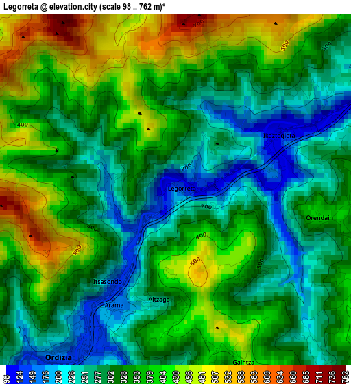
Below is the Elevation map of Legorreta, which displays elevation range with different colors. Scale of the first map is from 98 to 762 m (322 to 2500 ft) with average elevation of 338.9 meters (=1112 ft) [note 1]
These maps also provides idea of topography and contour of this city, they are displayed at different zoom levels. More info about maps, scale and edge coordinates you can find below images.
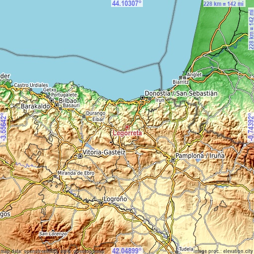
| \ | Map #1 | Topo.Map |
| Scale [m] | 98..762 m | × |
| Scale [ft] | 322..2500 ft | × |
| Average | 338.9 m = 1112 ft | × |
| Width | 7.14 km = 4.4 mi | 228.4 km = 141.9 mi |
| Height | 7.14 km = 4.4 mi | 228.4 km = 141.9 mi |
| ↑Max Latitude | 43.116727° | 44.10307° |
| Latitude at center | 43.08464° | 43.08464° |
| ↓Min Latitude | 43.052536° | 42.04899° |
| ← Min Longitude | -2.194115° | -3.55642° |
| Longitude center | -2.15017° | -2.15017° |
| →Max Longitude | -2.106225° | -0.74392° |
Nearby cities:
Cities around Legorreta sort by population:
• Albiztur elevation 280 m
5.1 km,  12°
12°
• Orendain 376 m
3.2 km,  101°
101°
• Arama 166 m
2.7 km,  207°
207°
• Baliarrain 290 m
2.5 km,  133°
133°
• Abaltzisketa 369 m
5.5 km,  138°
138°
• Zaldibia 172 m
5.3 km,  180°
180°
• Alegia 94 m
4.7 km,  67°
67°
• Ordizia 145 m
4 km, 212°
• Gaintza 438 m
3.8 km,  158°
158°
• Ikaztegieta 131 m
2.4 km,  63°
63°
• Altzaga 298 m
2.2 km,  187°
187°
• Itsasondo 153 m
2.1 km, 214°
Multilingual:
 En español:
Legorreta elevación 129 m.
 En France:
Legorreta élévation 129 m.
 Auf Deutsch:
Legorreta höhe über dem Meeresspiegel ist 129 m.

Sources and notes:
- [note 1] Map square and city borders are not equal. Map elevation data is calculated only from area inside that square.
- [src 1] Elevation data from geonames database provided with same terms of usage.
- [src 2] The elevation map of Legorreta is generated using elevation data from NASA's 3 arcsec (90m) resolution SRTM data.
- [src 3] Base (background) map © OpenStreetMap contributors tiles are generated by Geofabrik and OpenTopoMap.
Copyright & License:
This Legorreta Elevation Map is licensed under CC BY-SA. You may reuse any part from this page, if you give a proper credit by linking to this URL:
 More info on terms of use page.