Antillón elevation
Antillón (Aragon, Provincia de Huesca), Spain elevation is 479 meters and Antillón elevation in feet is 1572 ft above sea level [src 1]. Antillón is a seat of a third-order administrative division (feature code) with elevation that is 124 meters (407 ft) smaller than average city elevation in Spain.
Below is the Elevation map of Antillón, which displays elevation range with different colors. Scale of the first map is from 349 to 535 m (1145 to 1755 ft) with average elevation of 447.5 meters (=1468 ft) [note 1]
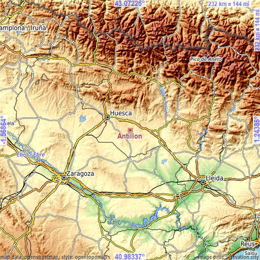
These maps also provides idea of topography and contour of this city, they are displayed at different zoom levels. More info about maps, scale and edge coordinates you can find below images.
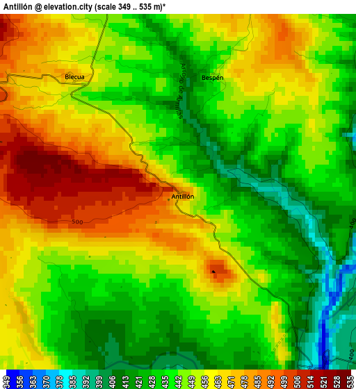
| \ | Map #1 | Topo.Map |
| Scale [m] | 349..535 m | × |
| Scale [ft] | 1145..1755 ft | × |
| Average | 447.5 m = 1468 ft | × |
| Width | 7.26 km = 4.5 mi | 232.3 km = 144.3 mi |
| Height | 7.26 km = 4.5 mi | 232.3 km = 144.3 mi |
| ↑Max Latitude | 42.069021° | 43.07225° |
| Latitude at center | 42.03639° | 42.03639° |
| ↓Min Latitude | 42.003743° | 40.98337° |
| ← Min Longitude | -0.206335° | -1.56864° |
| Longitude center | -0.16239° | -0.16239° |
| →Max Longitude | -0.118445° | 1.24386° |
Nearby cities:
Cities around Antillón sort by population:
• Angüés elevation 544 m
8.3 km,  5°
5°
• Laluenga 487 m
10.1 km,  108°
108°
• Sesa 430 m
8.2 km,  235°
235°
• Novales 457 m
10.3 km,  267°
267°
• Azara 436 m
11.6 km,  71°
71°
• Azlor 487 m
11.6 km,  56°
56°
• Pertusa 375 m
4.8 km,  142°
142°
• Argavieso 484 m
9.7 km,  280°
280°
• Torres de Alcanadre 391 m
8.8 km,  151°
151°
• Barbuñales 471 m
6.4 km,  100°
100°
• Salillas 428 m
6.8 km,  227°
227°
• Laperdiguera 460 m
10.8 km,  118°
118°
Multilingual:
 En español:
Antillón elevación 479 m.
 En France:
Antillón élévation 479 m.
 Auf Deutsch:
Antillón höhe über dem Meeresspiegel ist 479 m.

Sources and notes:
- [note 1] Map square and city borders are not equal. Map elevation data is calculated only from area inside that square.
- [src 1] Elevation data from geonames database provided with same terms of usage.
- [src 2] The elevation map of Antillón is generated using elevation data from NASA's 3 arcsec (90m) resolution SRTM data.
- [src 3] Base (background) map © OpenStreetMap contributors tiles are generated by Geofabrik and OpenTopoMap.
Copyright & License:
This Antillón Elevation Map is licensed under CC BY-SA. You may reuse any part from this page, if you give a proper credit by linking to this URL:
 More info on terms of use page.