Antzuola elevation
Antzuola (Basque Country, Gipuzkoa), Spain elevation is 240 meters and Antzuola elevation in feet is 787 ft above sea level [src 1]. Antzuola is a seat of a third-order administrative division (feature code) with elevation that is 363 meters (1191 ft) smaller than average city elevation in Spain.
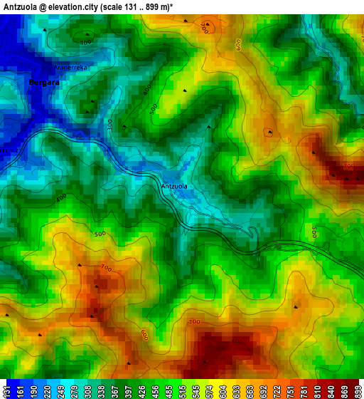
Below is the Elevation map of Antzuola, which displays elevation range with different colors. Scale of the first map is from 131 to 899 m (430 to 2949 ft) with average elevation of 480.6 meters (=1577 ft) [note 1]
These maps also provides idea of topography and contour of this city, they are displayed at different zoom levels. More info about maps, scale and edge coordinates you can find below images.
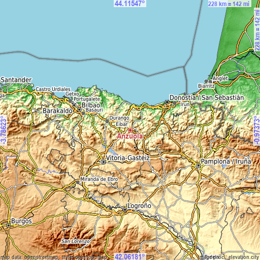
| \ | Map #1 | Topo.Map |
| Scale [m] | 131..899 m | × |
| Scale [ft] | 430..2949 ft | × |
| Average | 480.6 m = 1577 ft | × |
| Width | 7.14 km = 4.4 mi | 228.3 km = 141.9 mi |
| Height | 7.14 km = 4.4 mi | 228.3 km = 141.9 mi |
| ↑Max Latitude | 43.12933° | 44.11547° |
| Latitude at center | 43.09725° | 43.09725° |
| ↓Min Latitude | 43.065153° | 42.06181° |
| ← Min Longitude | -2.423925° | -3.78623° |
| Longitude center | -2.37998° | -2.37998° |
| →Max Longitude | -2.336035° | -0.97373° |
Nearby cities:
Cities around Antzuola sort by population:
• Arrasate / Mondragón elevation 211 m
9.6 km,  247°
247°
• Bergara 157 m
3.6 km,  303°
303°
• Azkoitia 115 m
10.5 km,  32°
32°
• Oñati 248 m
7.6 km,  198°
198°
• Zumarraga 364 m
5.4 km,  100°
100°
• Aretxabaleta 246 m
12.3 km,  235°
235°
• Mutiloa 240 m
12 km,  133°
133°
• Ormaiztegi 203 m
11.7 km,  120°
120°
• Elgeta 464 m
9.9 km, 296°
• Gabiria 401 m
9.7 km, 123°
• Legazpi 448 m
6 km,  144°
144°
• Urretxu 358 m
5.2 km, 97°
Multilingual:
 En español:
Anzuola elevación 240 m.
 En France:
Antzuola élévation 240 m.
 Auf Deutsch:
Antzuola höhe über dem Meeresspiegel ist 240 m.

Sources and notes:
- [note 1] Map square and city borders are not equal. Map elevation data is calculated only from area inside that square.
- [src 1] Elevation data from geonames database provided with same terms of usage.
- [src 2] The elevation map of Antzuola is generated using elevation data from NASA's 3 arcsec (90m) resolution SRTM data.
- [src 3] Base (background) map © OpenStreetMap contributors tiles are generated by Geofabrik and OpenTopoMap.
Copyright & License:
This Antzuola Elevation Map is licensed under CC BY-SA. You may reuse any part from this page, if you give a proper credit by linking to this URL:
 More info on terms of use page.