Oñati elevation
Oñati (Basque Country, Gipuzkoa), Spain elevation is 248 meters and Oñati elevation in feet is 814 ft above sea level [src 1]. Oñati is a seat of a third-order administrative division (feature code) with elevation that is 355 meters (1165 ft) smaller than average city elevation in Spain.
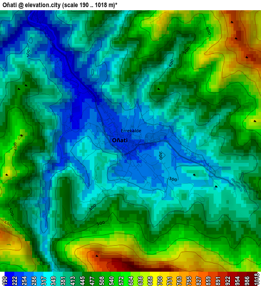
Below is the Elevation map of Oñati, which displays elevation range with different colors. Scale of the first map is from 190 to 1018 m (623 to 3340 ft) with average elevation of 441.9 meters (=1450 ft) [note 1]
These maps also provides idea of topography and contour of this city, they are displayed at different zoom levels. More info about maps, scale and edge coordinates you can find below images.
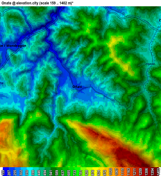
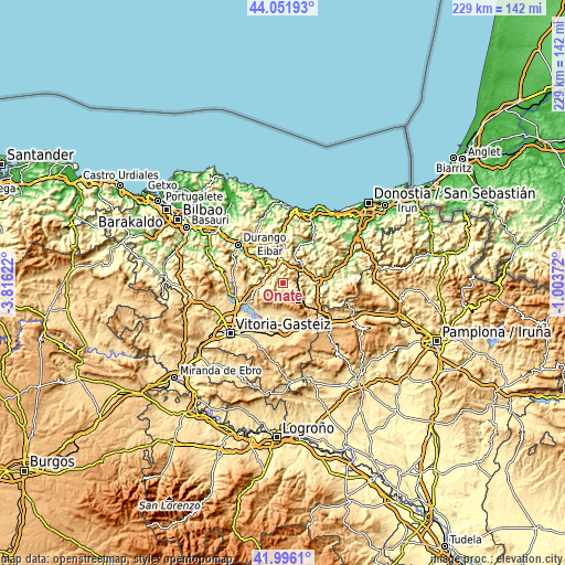
| \ | Map #1 | Map #2 | Topo.Map |
| Scale [m] | 190..1018 m | 159..1402 m | × |
| Scale [ft] | 623..3340 ft | 522..4600 ft | × |
| Average | 441.9 m = 1450 ft | 556.2 m = 1825 ft | × |
| Width | 7.14 km = 4.4 mi | 14.29 km = 8.9 mi | 228.6 km = 142 mi |
| Height | 7.14 km = 4.4 mi | 14.29 km = 8.9 mi | 228.6 km = 142 mi |
| ↑Max Latitude | 43.064734° | 43.096831° | 44.05193° |
| Latitude at center | 43.03262° | 43.03262° | 43.03262° |
| ↓Min Latitude | 43.000489° | 42.968341° | 41.9961° |
| ← Min Longitude | -2.453915° | -2.497861° | -3.81622° |
| Longitude center | -2.40997° | -2.40997° | -2.40997° |
| →Max Longitude | -2.366025° | -2.322079° | -1.00372° |
Nearby cities:
Cities around Oñati sort by population:
• Arrasate / Mondragón elevation 211 m
7.4 km,  298°
298°
• Bergara 157 m
9.2 km,  356°
356°
• Zumarraga 364 m
10 km,  51°
51°
• Aretxabaleta 246 m
7.7 km,  271°
271°
• Eskoriatza 284 m
9.6 km,  260°
260°
• Mutiloa 240 m
11.2 km,  95°
95°
• Zegama 301 m
11.6 km,  123°
123°
• Zerain 326 m
11.4 km, 101°
• Gabiria 401 m
10.8 km,  80°
80°
• Urretxu 358 m
10 km, 49°
• Antzuola 240 m
7.6 km,  18°
18°
• Legazpi 448 m
6.4 km,  68°
68°
Multilingual:
 En español:
Oñate elevación 248 m.
 En France:
Oñati élévation 248 m.


Sources and notes:
- [note 1] Map square and city borders are not equal. Map elevation data is calculated only from area inside that square.
- [src 1] Elevation data from geonames database provided with same terms of usage.
- [src 2] The elevation map of Oñati is generated using elevation data from NASA's 3 arcsec (90m) resolution SRTM data.
- [src 3] Base (background) map © OpenStreetMap contributors tiles are generated by Geofabrik and OpenTopoMap.
Copyright & License:
This Oñati Elevation Map is licensed under CC BY-SA. You may reuse any part from this page, if you give a proper credit by linking to this URL:
 More info on terms of use page.