Aranda de Moncayo elevation
Aranda de Moncayo (Aragon, Provincia de Zaragoza), Spain elevation is 900 meters and Aranda de Moncayo elevation in feet is 2953 ft above sea level [src 1]. Aranda de Moncayo is a seat of a third-order administrative division (feature code) with elevation that is 297 meters (974 ft) bigger than average city elevation in Spain.
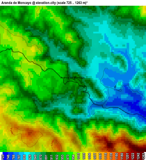
Below is the Elevation map of Aranda de Moncayo, which displays elevation range with different colors. Scale of the first map is from 725 to 1263 m (2379 to 4144 ft) with average elevation of 930 meters (=3051 ft) [note 1]
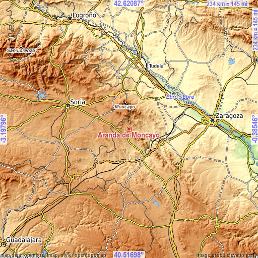
These maps also provides idea of topography and contour of this city, they are displayed at different zoom levels. More info about maps, scale and edge coordinates you can find below images.
| \ | Map #1 | Topo.Map |
| Scale [m] | 725..1263 m | × |
| Scale [ft] | 2379..4144 ft | × |
| Average | 930 m = 3051 ft | × |
| Width | 7.31 km = 4.5 mi | 233.9 km = 145.3 mi |
| Height | 7.31 km = 4.5 mi | 233.9 km = 145.3 mi |
| ↑Max Latitude | 41.610355° | 42.62087° |
| Latitude at center | 41.57749° | 41.57749° |
| ↓Min Latitude | 41.544608° | 40.51698° |
| ← Min Longitude | -1.835655° | -3.19796° |
| Longitude center | -1.79171° | -1.79171° |
| →Max Longitude | -1.747765° | -0.38546° |
Nearby cities:
Cities around Aranda de Moncayo sort by population:
• Villarroya de la Sierra elevation 749 m
12.7 km,  176°
176°
• Jarque 642 m
9.9 km,  103°
103°
• Gotor 612 m
12.4 km,  106°
106°
• Borobia 1137 m
13 km,  318°
318°
• Malanquilla 1050 m
7 km,  261°
261°
• Bijuesca 933 m
11.5 km,  249°
249°
• Clarés de Ribota 940 m
6.6 km,  215°
215°
• Berdejo 985 m
12.8 km, 261°
• Calcena 830 m
10.6 km,  35°
35°
• Purujosa 964 m
11.9 km,  10°
10°
• Oseja 827 m
7.9 km,  75°
75°
• Pomer 1099 m
7.8 km,  328°
328°
Multilingual:
 En español:
Aranda de Moncayo elevación 900 m.
 En France:
Aranda de Moncayo élévation 900 m.
 Auf Deutsch:
Aranda de Moncayo höhe über dem Meeresspiegel ist 900 m.

Sources and notes:
- [note 1] Map square and city borders are not equal. Map elevation data is calculated only from area inside that square.
- [src 1] Elevation data from geonames database provided with same terms of usage.
- [src 2] The elevation map of Aranda de Moncayo is generated using elevation data from NASA's 3 arcsec (90m) resolution SRTM data.
- [src 3] Base (background) map © OpenStreetMap contributors tiles are generated by Geofabrik and OpenTopoMap.
Copyright & License:
This Aranda de Moncayo Elevation Map is licensed under CC BY-SA. You may reuse any part from this page, if you give a proper credit by linking to this URL:
 More info on terms of use page.