Oseja elevation
Oseja (Aragon, Provincia de Zaragoza), Spain elevation is 827 meters and Oseja elevation in feet is 2713 ft above sea level [src 1]. Oseja is a seat of a third-order administrative division (feature code) with elevation that is 224 meters (735 ft) bigger than average city elevation in Spain.
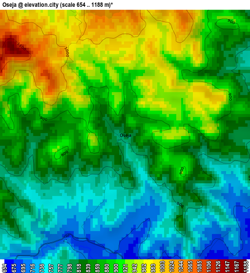
Below is the Elevation map of Oseja, which displays elevation range with different colors. Scale of the first map is from 654 to 1188 m (2146 to 3898 ft) with average elevation of 854.9 meters (=2805 ft) [note 1]
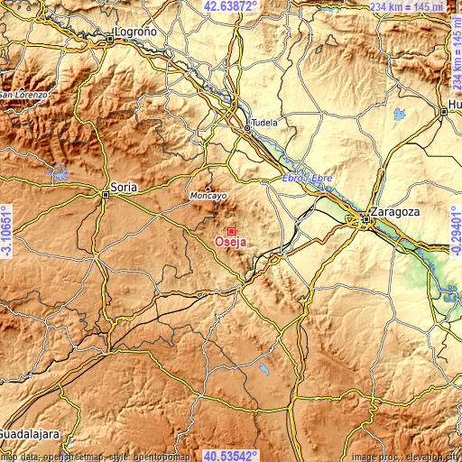
These maps also provides idea of topography and contour of this city, they are displayed at different zoom levels. More info about maps, scale and edge coordinates you can find below images.
| \ | Map #1 | Topo.Map |
| Scale [m] | 654..1188 m | × |
| Scale [ft] | 2146..3898 ft | × |
| Average | 854.9 m = 2805 ft | × |
| Width | 7.31 km = 4.5 mi | 233.9 km = 145.3 mi |
| Height | 7.31 km = 4.5 mi | 233.9 km = 145.3 mi |
| ↑Max Latitude | 41.628496° | 42.63872° |
| Latitude at center | 41.59564° | 41.59564° |
| ↓Min Latitude | 41.562767° | 40.53542° |
| ← Min Longitude | -1.744205° | -3.10651° |
| Longitude center | -1.70026° | -1.70026° |
| →Max Longitude | -1.656315° | -0.29401° |
Nearby cities:
Cities around Oseja sort by population:
• Illueca elevation 588 m
8.8 km,  136°
136°
• Brea de Aragón 559 m
11.4 km,  134°
134°
• Jarque 642 m
4.8 km,  154°
154°
• Gotor 612 m
7 km, 142°
• Mesones de Isuela 518 m
14.3 km,  110°
110°
• Aranda de Moncayo 900 m
7.9 km,  255°
255°
• Trasobares 674 m
7.2 km,  42°
42°
• Malanquilla 1050 m
14.8 km, 258°
• Clarés de Ribota 940 m
13.6 km,  237°
237°
• Calcena 830 m
6.8 km,  347°
347°
• Purujosa 964 m
11.1 km,  330°
330°
• Pomer 1099 m
12.6 km,  291°
291°
Multilingual:
 En español:
Oseja elevación 827 m.
 En France:
Oseja élévation 827 m.


Sources and notes:
- [note 1] Map square and city borders are not equal. Map elevation data is calculated only from area inside that square.
- [src 1] Elevation data from geonames database provided with same terms of usage.
- [src 2] The elevation map of Oseja is generated using elevation data from NASA's 3 arcsec (90m) resolution SRTM data.
- [src 3] Base (background) map © OpenStreetMap contributors tiles are generated by Geofabrik and OpenTopoMap.
Copyright & License:
This Oseja Elevation Map is licensed under CC BY-SA. You may reuse any part from this page, if you give a proper credit by linking to this URL:
 More info on terms of use page.