Arañuel elevation
Arañuel (Valencia, Província de Castelló), Spain elevation is 508 meters and Arañuel elevation in feet is 1667 ft above sea level [src 1]. Arañuel is a seat of a third-order administrative division (feature code) with elevation that is 95 meters (312 ft) smaller than average city elevation in Spain.
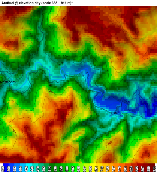
Below is the Elevation map of Arañuel, which displays elevation range with different colors. Scale of the first map is from 338 to 911 m (1109 to 2989 ft) with average elevation of 645.6 meters (=2118 ft) [note 1]
These maps also provides idea of topography and contour of this city, they are displayed at different zoom levels. More info about maps, scale and edge coordinates you can find below images.
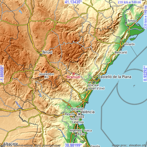
| \ | Map #1 | Topo.Map |
| Scale [m] | 338..911 m | × |
| Scale [ft] | 1109..2989 ft | × |
| Average | 645.6 m = 2118 ft | × |
| Width | 7.48 km = 4.6 mi | 239.3 km = 148.7 mi |
| Height | 7.48 km = 4.6 mi | 239.3 km = 148.7 mi |
| ↑Max Latitude | 40.100293° | 41.13435° |
| Latitude at center | 40.06667° | 40.06667° |
| ↓Min Latitude | 40.033031° | 38.98199° |
| ← Min Longitude | -0.527275° | -1.88958° |
| Longitude center | -0.48333° | -0.48333° |
| →Max Longitude | -0.439385° | 0.92292° |
Nearby cities:
Cities around Arañuel sort by population:
• Montanejos elevation 461 m
2.8 km,  270°
270°
• Montán 573 m
6.8 km,  236°
236°
• Cirat 447 m
3.4 km,  123°
123°
• Ludiente 538 m
10.1 km,  79°
79°
• Zucaina 713 m
7.9 km,  45°
45°
• Puebla de Arenoso 740 m
9.3 km,  293°
293°
• Torrechiva 323 m
7.3 km,  104°
104°
• Fuentes de Ayódar 676 m
6.8 km, 123°
• Toga 401 m
10.1 km, 100°
• Higueras 688 m
9.4 km,  188°
188°
• Torralba del Pinar 805 m
10.2 km,  155°
155°
• Fuente la Reina 763 m
9.9 km, 270°
Multilingual:
 En español:
Arañuel elevación 508 m.
 En France:
Arañuel élévation 508 m.


Sources and notes:
- [note 1] Map square and city borders are not equal. Map elevation data is calculated only from area inside that square.
- [src 1] Elevation data from geonames database provided with same terms of usage.
- [src 2] The elevation map of Arañuel is generated using elevation data from NASA's 3 arcsec (90m) resolution SRTM data.
- [src 3] Base (background) map © OpenStreetMap contributors tiles are generated by Geofabrik and OpenTopoMap.
Copyright & License:
This Arañuel Elevation Map is licensed under CC BY-SA. You may reuse any part from this page, if you give a proper credit by linking to this URL:
 More info on terms of use page.