Torrechiva elevation
Torrechiva (Valencia, Província de Castelló), Spain elevation is 323 meters and Torrechiva elevation in feet is 1060 ft above sea level [src 1]. Torrechiva is a seat of a third-order administrative division (feature code) with elevation that is 280 meters (919 ft) smaller than average city elevation in Spain.
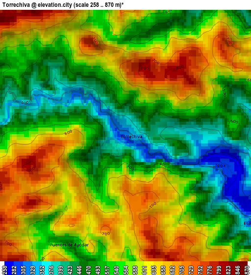
Below is the Elevation map of Torrechiva, which displays elevation range with different colors. Scale of the first map is from 258 to 870 m (846 to 2854 ft) with average elevation of 563.1 meters (=1847 ft) [note 1]
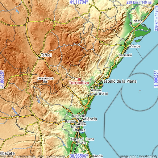
These maps also provides idea of topography and contour of this city, they are displayed at different zoom levels. More info about maps, scale and edge coordinates you can find below images.
| \ | Map #1 | Topo.Map |
| Scale [m] | 258..870 m | × |
| Scale [ft] | 846..2854 ft | × |
| Average | 563.1 m = 1847 ft | × |
| Width | 7.48 km = 4.6 mi | 239.4 km = 148.8 mi |
| Height | 7.48 km = 4.6 mi | 239.4 km = 148.8 mi |
| ↑Max Latitude | 40.083631° | 41.11794° |
| Latitude at center | 40.05° | 40.05° |
| ↓Min Latitude | 40.016352° | 38.96506° |
| ← Min Longitude | -0.443945° | -1.80625° |
| Longitude center | -0.4° | -0.4° |
| →Max Longitude | -0.356055° | 1.00625° |
Nearby cities:
Cities around Torrechiva sort by population:
• Cirat elevation 447 m
4.3 km,  270°
270°
• Fanzara 217 m
8 km,  117°
117°
• Ayódar 443 m
6.2 km,  152°
152°
• Ludiente 538 m
4.7 km,  37°
37°
• Zucaina 713 m
7.5 km,  349°
349°
• Arañuel 508 m
7.3 km,  284°
284°
• Argelita 291 m
4.3 km,  90°
90°
• Villamalur 554 m
9.3 km,  180°
180°
• Fuentes de Ayódar 676 m
2.3 km,  217°
217°
• Toga 401 m
2.8 km, 90°
• Torralba del Pinar 805 m
7.9 km,  200°
200°
• Espadilla 250 m
4.6 km,  113°
113°
Multilingual:
 En español:
Torrechiva elevación 323 m.
 En France:
Torrechiva élévation 323 m.
 Auf Deutsch:
Torrechiva höhe über dem Meeresspiegel ist 323 m.

Sources and notes:
- [note 1] Map square and city borders are not equal. Map elevation data is calculated only from area inside that square.
- [src 1] Elevation data from geonames database provided with same terms of usage.
- [src 2] The elevation map of Torrechiva is generated using elevation data from NASA's 3 arcsec (90m) resolution SRTM data.
- [src 3] Base (background) map © OpenStreetMap contributors tiles are generated by Geofabrik and OpenTopoMap.
Copyright & License:
This Torrechiva Elevation Map is licensed under CC BY-SA. You may reuse any part from this page, if you give a proper credit by linking to this URL:
 More info on terms of use page.