Arguis elevation
Arguis (Aragon, Provincia de Huesca), Spain elevation is 1040 meters and Arguis elevation in feet is 3412 ft above sea level [src 1]. Arguis is a seat of a third-order administrative division (feature code) with elevation that is 437 meters (1434 ft) bigger than average city elevation in Spain.
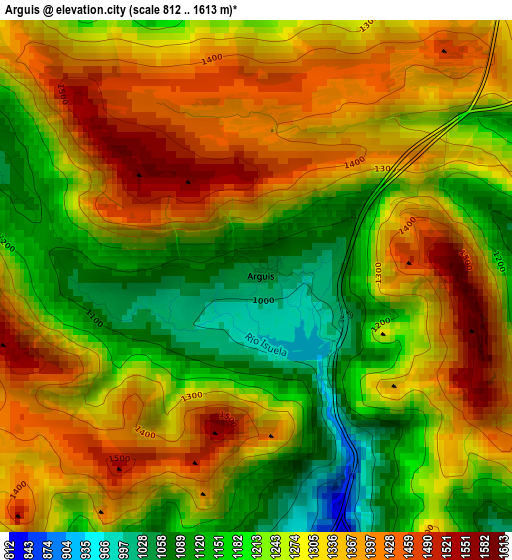
Below is the Elevation map of Arguis, which displays elevation range with different colors. Scale of the first map is from 812 to 1613 m (2664 to 5292 ft) with average elevation of 1279.5 meters (=4198 ft) [note 1]
These maps also provides idea of topography and contour of this city, they are displayed at different zoom levels. More info about maps, scale and edge coordinates you can find below images.
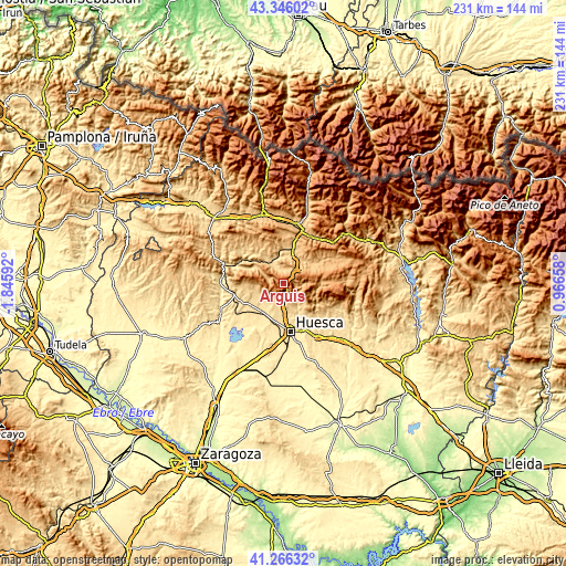
| \ | Map #1 | Topo.Map |
| Scale [m] | 812..1613 m | × |
| Scale [ft] | 2664..5292 ft | × |
| Average | 1279.5 m = 4198 ft | × |
| Width | 7.23 km = 4.5 mi | 231.2 km = 143.7 mi |
| Height | 7.23 km = 4.5 mi | 231.2 km = 143.7 mi |
| ↑Max Latitude | 42.347247° | 43.34602° |
| Latitude at center | 42.31476° | 42.31476° |
| ↓Min Latitude | 42.282256° | 41.26632° |
| ← Min Longitude | -0.483615° | -1.84592° |
| Longitude center | -0.43967° | -0.43967° |
| →Max Longitude | -0.395725° | 0.96658° |
Nearby cities:
Cities around Arguis sort by population:
• Huesca elevation 476 m
20 km,  172°
172°
• Ayerbe 573 m
21 km,  257°
257°
• Loporzano 584 m
19.6 km,  150°
150°
• Nueno 726 m
5.3 km,  179°
179°
• Loarre 783 m
15.3 km,  269°
269°
• Igriés 607 m
11.2 km, 176°
• Tierz 466 m
21.3 km,  160°
160°
• Chimillas 522 m
16.1 km, 183°
• Quicena 477 m
19.7 km, 160°
• Banastás 534 m
14.9 km, 183°
• Alerre 509 m
16.8 km,  186°
186°
• Loscorrales 622 m
18 km,  248°
248°
Multilingual:
 En español:
Arguis elevación 1040 m.
 En France:
Arguis élévation 1040 m.


Sources and notes:
- [note 1] Map square and city borders are not equal. Map elevation data is calculated only from area inside that square.
- [src 1] Elevation data from geonames database provided with same terms of usage.
- [src 2] The elevation map of Arguis is generated using elevation data from NASA's 3 arcsec (90m) resolution SRTM data.
- [src 3] Base (background) map © OpenStreetMap contributors tiles are generated by Geofabrik and OpenTopoMap.
Copyright & License:
This Arguis Elevation Map is licensed under CC BY-SA. You may reuse any part from this page, if you give a proper credit by linking to this URL:
 More info on terms of use page.