Ayerbe elevation
Ayerbe (Aragon, Provincia de Huesca), Spain elevation is 573 meters and Ayerbe elevation in feet is 1880 ft above sea level [src 1]. Ayerbe is a populated place (feature code) with elevation that is 30 meters (98 ft) smaller than average city elevation in Spain.
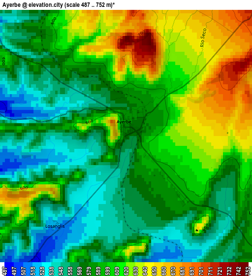
Below is the Elevation map of Ayerbe, which displays elevation range with different colors. Scale of the first map is from 487 to 752 m (1598 to 2467 ft) with average elevation of 591.9 meters (=1942 ft) [note 1]
These maps also provides idea of topography and contour of this city, they are displayed at different zoom levels. More info about maps, scale and edge coordinates you can find below images.
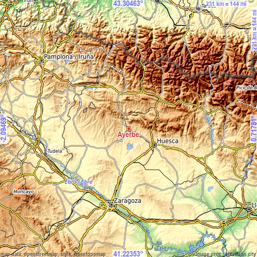
| \ | Map #1 | Topo.Map |
| Scale [m] | 487..752 m | × |
| Scale [ft] | 1598..2467 ft | × |
| Average | 591.9 m = 1942 ft | × |
| Width | 7.23 km = 4.5 mi | 231.4 km = 143.8 mi |
| Height | 7.23 km = 4.5 mi | 231.4 km = 143.8 mi |
| ↑Max Latitude | 42.305179° | 43.30463° |
| Latitude at center | 42.27267° | 42.27267° |
| ↓Min Latitude | 42.240144° | 41.22353° |
| ← Min Longitude | -0.732385° | -2.09469° |
| Longitude center | -0.68844° | -0.68844° |
| →Max Longitude | -0.644495° | 0.71781° |
Nearby cities:
Cities around Ayerbe sort by population:
• Nueno elevation 726 m
20.5 km,  91°
91°
• Loarre 783 m
6.9 km,  48°
48°
• Igriés 607 m
22.1 km,  107°
107°
• Banastás 534 m
22 km,  117°
117°
• Biscarrués 465 m
7 km,  225°
225°
• Piedratajada 419 m
19.3 km,  209°
209°
• Valpalmas 497 m
18.7 km, 227°
• Agüero 688 m
12.6 km,  316°
316°
• Santa Eulalia de Gállego 509 m
6.2 km,  285°
285°
• Loscorrales 622 m
4.3 km, 118°
• Marracos 402 m
21.7 km,  199°
199°
• Arguis 1040 m
21 km,  77°
77°
Multilingual:
 En español:
Ayerbe elevación 573 m.
 En France:
Ayerbe élévation 573 m.


Sources and notes:
- [note 1] Map square and city borders are not equal. Map elevation data is calculated only from area inside that square.
- [src 1] Elevation data from geonames database provided with same terms of usage.
- [src 2] The elevation map of Ayerbe is generated using elevation data from NASA's 3 arcsec (90m) resolution SRTM data.
- [src 3] Base (background) map © OpenStreetMap contributors tiles are generated by Geofabrik and OpenTopoMap.
Copyright & License:
This Ayerbe Elevation Map is licensed under CC BY-SA. You may reuse any part from this page, if you give a proper credit by linking to this URL:
 More info on terms of use page.