Arrabalde elevation
Arrabalde (Castille and León, Provincia de Zamora), Spain elevation is 776 meters and Arrabalde elevation in feet is 2546 ft above sea level [src 1]. Arrabalde is a seat of a third-order administrative division (feature code) with elevation that is 173 meters (568 ft) bigger than average city elevation in Spain.
Below is the Elevation map of Arrabalde, which displays elevation range with different colors. Scale of the first map is from 739 to 989 m (2425 to 3245 ft) with average elevation of 802.4 meters (=2633 ft) [note 1]
These maps also provides idea of topography and contour of this city, they are displayed at different zoom levels. More info about maps, scale and edge coordinates you can find below images.
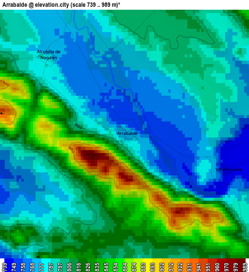
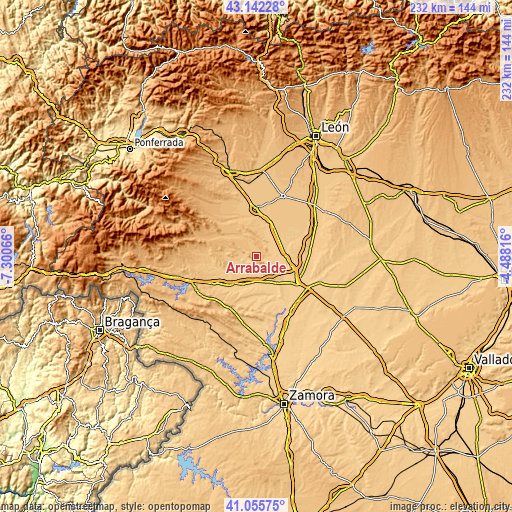
| \ | Map #1 | Topo.Map |
| Scale [m] | 739..989 m | × |
| Scale [ft] | 2425..3245 ft | × |
| Average | 802.4 m = 2633 ft | × |
| Width | 7.25 km = 4.5 mi | 232 km = 144.2 mi |
| Height | 7.25 km = 4.5 mi | 232 km = 144.2 mi |
| ↑Max Latitude | 42.140194° | 43.14228° |
| Latitude at center | 42.1076° | 42.1076° |
| ↓Min Latitude | 42.074989° | 41.05575° |
| ← Min Longitude | -5.938355° | -7.30066° |
| Longitude center | -5.89441° | -5.89441° |
| →Max Longitude | -5.850465° | -4.48816° |
Nearby cities:
Cities around Arrabalde sort by population:
• Santa María de la Vega elevation 729 m
7.5 km,  109°
109°
• San Esteban de Nogales 785 m
6.5 km,  332°
332°
• Coomonte 735 m
6.8 km,  82°
82°
• Maire de Castroponce 742 m
9.1 km,  86°
86°
• Granucillo 722 m
6.8 km,  204°
204°
• Fresno de la Polvorosa 724 m
10.6 km,  104°
104°
• Alcubilla de Nogales 779 m
3.2 km,  314°
314°
• Villaferrueña 744 m
3.2 km, 109°
• Brime de Urz 719 m
7.9 km,  167°
167°
• Quintanilla de Urz 715 m
9.1 km,  155°
155°
• Fuente Encalada 752 m
8.4 km,  271°
271°
• Villageriz 779 m
5.2 km,  283°
283°
Multilingual:
 En español:
Arrabalde elevación 776 m.
 En France:
Arrabalde élévation 776 m.
 Auf Deutsch:
Arrabalde höhe über dem Meeresspiegel ist 776 m.

Sources and notes:
- [note 1] Map square and city borders are not equal. Map elevation data is calculated only from area inside that square.
- [src 1] Elevation data from geonames database provided with same terms of usage.
- [src 2] The elevation map of Arrabalde is generated using elevation data from NASA's 3 arcsec (90m) resolution SRTM data.
- [src 3] Base (background) map © OpenStreetMap contributors tiles are generated by Geofabrik and OpenTopoMap.
Copyright & License:
This Arrabalde Elevation Map is licensed under CC BY-SA. You may reuse any part from this page, if you give a proper credit by linking to this URL:
 More info on terms of use page.