Arroyomolinos elevation
Arroyomolinos (Madrid, Provincia de Madrid), Spain elevation is 598 meters and Arroyomolinos elevation in feet is 1962 ft above sea level [src 1]. Arroyomolinos is a populated place (feature code) with elevation that is 5 meters (16 ft) smaller than average city elevation in Spain.
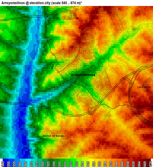
Below is the Elevation map of Arroyomolinos, which displays elevation range with different colors. Scale of the first map is from 545 to 674 m (1788 to 2211 ft) with average elevation of 615.7 meters (=2020 ft) [note 1]
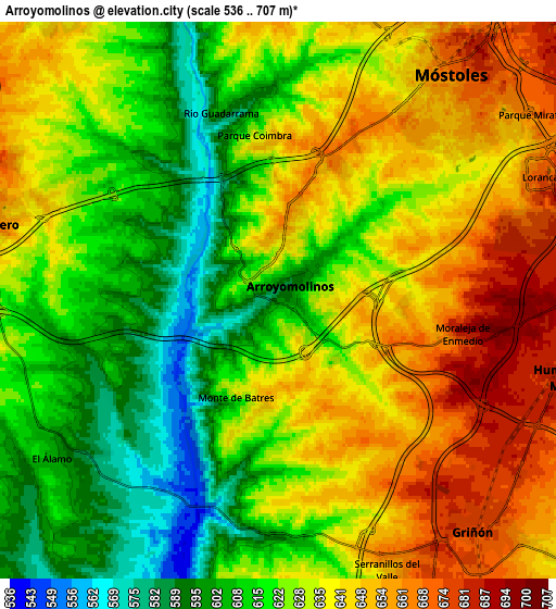
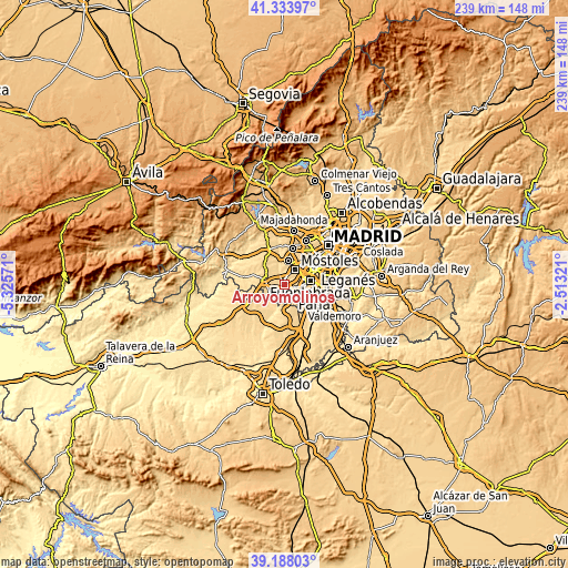
These maps also provides idea of topography and contour of this city, they are displayed at different zoom levels. More info about maps, scale and edge coordinates you can find below images.
| \ | Map #1 | Map #2 | Topo.Map |
| Scale [m] | 545..674 m | 536..707 m | × |
| Scale [ft] | 1788..2211 ft | 1759..2320 ft | × |
| Average | 615.7 m = 2020 ft | 629.3 m = 2065 ft | × |
| Width | 7.46 km = 4.6 mi | 14.91 km = 9.3 mi | 238.6 km = 148.3 mi |
| Height | 7.46 km = 4.6 mi | 14.91 km = 9.3 mi | 238.6 km = 148.3 mi |
| ↑Max Latitude | 40.303033° | 40.336538° | 41.33397° |
| Latitude at center | 40.26951° | 40.26951° | 40.26951° |
| ↓Min Latitude | 40.235971° | 40.202415° | 39.18803° |
| ← Min Longitude | -3.963405° | -4.007351° | -5.32571° |
| Longitude center | -3.91946° | -3.91946° | -3.91946° |
| →Max Longitude | -3.875515° | -3.831569° | -2.51321° |
Nearby cities:
Cities around Arroyomolinos sort by population:
• Móstoles elevation 667 m
7.5 km,  38°
38°
• Fuenlabrada 671 m
10.8 km,  81°
81°
• Villaviciosa de Odón 648 m
9.9 km,  7°
7°
• Navalcarnero 663 m
8.1 km,  285°
285°
• Humanes de Madrid 680 m
7.8 km,  105°
105°
• Griñón 676 m
8.4 km,  139°
139°
• El Álamo 608 m
7.7 km,  235°
235°
• Moraleja de Enmedio 692 m
5.2 km,  100°
100°
• Cubas 645 m
11.5 km, 141°
• Serranillos del Valle 662 m
8.1 km,  156°
156°
• Carranque 662 m
11.2 km,  171°
171°
• Batres 602 m
6.6 km,  182°
182°
Multilingual:
 En español:
Arroyomolinos elevación 598 m.
 En France:
Arroyomolinos élévation 598 m.
 Auf Deutsch:
Arroyomolinos höhe über dem Meeresspiegel ist 598 m.

Sources and notes:
- [note 1] Map square and city borders are not equal. Map elevation data is calculated only from area inside that square.
- [src 1] Elevation data from geonames database provided with same terms of usage.
- [src 2] The elevation map of Arroyomolinos is generated using elevation data from NASA's 3 arcsec (90m) resolution SRTM data.
- [src 3] Base (background) map © OpenStreetMap contributors tiles are generated by Geofabrik and OpenTopoMap.
Copyright & License:
This Arroyomolinos Elevation Map is licensed under CC BY-SA. You may reuse any part from this page, if you give a proper credit by linking to this URL:
 More info on terms of use page.