Batres elevation
Batres (Madrid, Provincia de Madrid), Spain elevation is 602 meters and Batres elevation in feet is 1975 ft above sea level [src 1]. Batres is a seat of a third-order administrative division (feature code) with elevation that is 1 meters (3 ft) smaller than average city elevation in Spain.
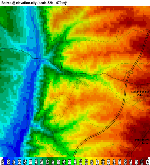
Below is the Elevation map of Batres, which displays elevation range with different colors. Scale of the first map is from 529 to 679 m (1736 to 2228 ft) with average elevation of 609.6 meters (=2000 ft) [note 1]
These maps also provides idea of topography and contour of this city, they are displayed at different zoom levels. More info about maps, scale and edge coordinates you can find below images.
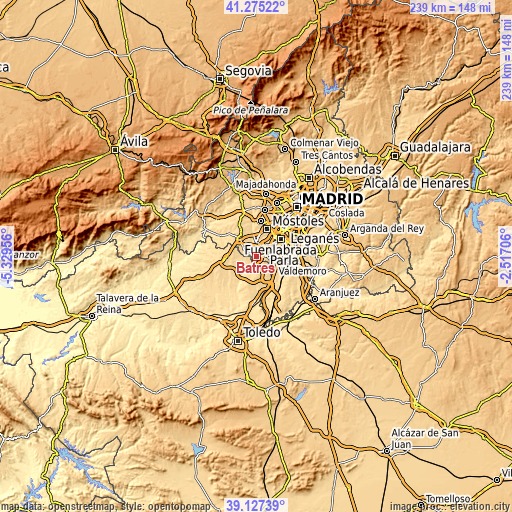
| \ | Map #1 | Topo.Map |
| Scale [m] | 529..679 m | × |
| Scale [ft] | 1736..2228 ft | × |
| Average | 609.6 m = 2000 ft | × |
| Width | 7.46 km = 4.6 mi | 238.8 km = 148.4 mi |
| Height | 7.46 km = 4.6 mi | 238.8 km = 148.4 mi |
| ↑Max Latitude | 40.243362° | 41.27522° |
| Latitude at center | 40.20981° | 40.20981° |
| ↓Min Latitude | 40.176241° | 39.12739° |
| ← Min Longitude | -3.967255° | -5.32956° |
| Longitude center | -3.92331° | -3.92331° |
| →Max Longitude | -3.879365° | -2.51706° |
Nearby cities:
Cities around Batres sort by population:
• Humanes de Madrid elevation 680 m
9.1 km,  60°
60°
• Arroyomolinos 598 m
6.6 km,  2°
2°
• Griñón 676 m
5.8 km,  87°
87°
• El Álamo 608 m
6.5 km,  290°
290°
• Moraleja de Enmedio 692 m
7.9 km,  43°
43°
• Casarrubios del Monte 620 m
9.9 km,  255°
255°
• Ugena 656 m
7.2 km,  146°
146°
• Cubas 645 m
7.8 km,  107°
107°
• Serranillos del Valle 662 m
3.6 km,  103°
103°
• Carranque 662 m
4.8 km,  156°
156°
• Casarrubuelos 626 m
8.9 km,  118°
118°
• El Viso de San Juan 654 m
7.6 km,  176°
176°
Multilingual:
 En español:
Batres elevación 602 m.
 En France:
Batres élévation 602 m.


Sources and notes:
- [note 1] Map square and city borders are not equal. Map elevation data is calculated only from area inside that square.
- [src 1] Elevation data from geonames database provided with same terms of usage.
- [src 2] The elevation map of Batres is generated using elevation data from NASA's 3 arcsec (90m) resolution SRTM data.
- [src 3] Base (background) map © OpenStreetMap contributors tiles are generated by Geofabrik and OpenTopoMap.
Copyright & License:
This Batres Elevation Map is licensed under CC BY-SA. You may reuse any part from this page, if you give a proper credit by linking to this URL:
 More info on terms of use page.