Arzúa elevation
Arzúa (Galicia, Provincia da Coruña), Spain elevation is 408 meters and Arzúa elevation in feet is 1339 ft above sea level [src 1]. Arzúa is a populated place (feature code) with elevation that is 195 meters (640 ft) smaller than average city elevation in Spain.
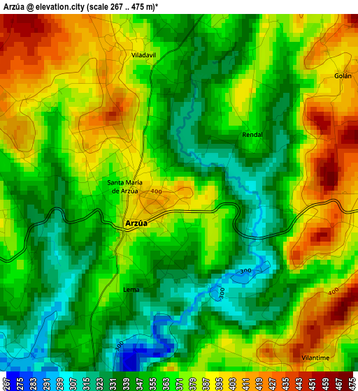
Below is the Elevation map of Arzúa, which displays elevation range with different colors. Scale of the first map is from 267 to 475 m (876 to 1558 ft) with average elevation of 365.8 meters (=1200 ft) [note 1]
These maps also provides idea of topography and contour of this city, they are displayed at different zoom levels. More info about maps, scale and edge coordinates you can find below images.
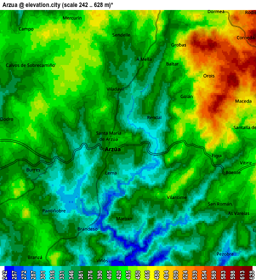
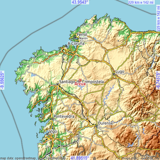
| \ | Map #1 | Map #2 | Topo.Map |
| Scale [m] | 267..475 m | 242..628 m | × |
| Scale [ft] | 876..1558 ft | 794..2060 ft | × |
| Average | 365.8 m = 1200 ft | 394.4 m = 1294 ft | × |
| Width | 7.15 km = 4.4 mi | 14.31 km = 8.9 mi | 229 km = 142.3 mi |
| Height | 7.15 km = 4.4 mi | 14.31 km = 8.9 mi | 228.9 km = 142.2 mi |
| ↑Max Latitude | 42.965496° | 42.997645° | 43.9543° |
| Latitude at center | 42.93333° | 42.93333° | 42.93333° |
| ↓Min Latitude | 42.901147° | 42.868948° | 41.89515° |
| ← Min Longitude | -8.193945° | -8.237891° | -9.55625° |
| Longitude center | -8.15° | -8.15° | -8.15° |
| →Max Longitude | -8.106055° | -8.062109° | -6.74375° |
Nearby cities:
Cities around Arzúa sort by population:
• Ordes elevation 277 m
26.4 km,  307°
307°
• Oroso 274 m
23.7 km,  283°
283°
• Touro 325 m
14.7 km,  240°
240°
• Mesia 378 m
20.8 km,  332°
332°
• Boimorto 482 m
7.5 km,  10°
10°
• Cesuras 329 m
26.9 km,  351°
351°
• Sobrado 504 m
15.4 km,  40°
40°
• Vilasantar 435 m
15.5 km, 8°
• Curtis 534 m
21.2 km,  0°
0°
• Frades 361 m
17.5 km,  317°
317°
• Melide 457 m
11.2 km,  101°
101°
• Santiso 373 m
10.2 km,  130°
130°
Multilingual:
 En español:
Arzúa elevación 408 m.
 En France:
Arzúa élévation 408 m.


Sources and notes:
- [note 1] Map square and city borders are not equal. Map elevation data is calculated only from area inside that square.
- [src 1] Elevation data from geonames database provided with same terms of usage.
- [src 2] The elevation map of Arzúa is generated using elevation data from NASA's 3 arcsec (90m) resolution SRTM data.
- [src 3] Base (background) map © OpenStreetMap contributors tiles are generated by Geofabrik and OpenTopoMap.
Copyright & License:
This Arzúa Elevation Map is licensed under CC BY-SA. You may reuse any part from this page, if you give a proper credit by linking to this URL:
 More info on terms of use page.