Astorga elevation
Astorga (Castille and León, Provincia de León), Spain elevation is 865 meters and Astorga elevation in feet is 2838 ft above sea level [src 1]. Astorga is a seat of a third-order administrative division (feature code) with elevation that is 262 meters (860 ft) bigger than average city elevation in Spain.
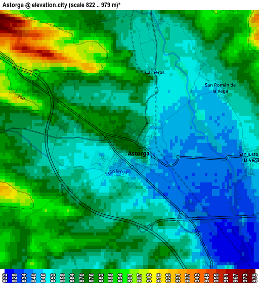
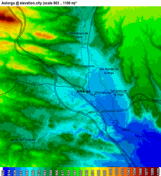
Below is the Elevation map of Astorga, which displays elevation range with different colors. Scale of the first map is from 822 to 979 m (2697 to 3212 ft) with average elevation of 866.2 meters (=2842 ft) [note 1]
These maps also provides idea of topography and contour of this city, they are displayed at different zoom levels. More info about maps, scale and edge coordinates you can find below images.
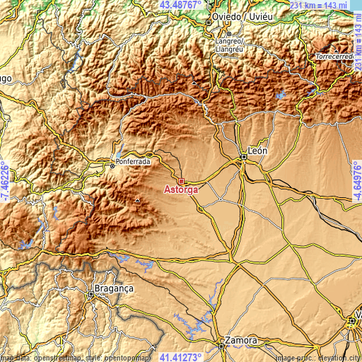
| \ | Map #1 | Map #2 | Topo.Map |
| Scale [m] | 822..979 m | 803..1100 m | × |
| Scale [ft] | 2697..3212 ft | 2635..3609 ft | × |
| Average | 866.2 m = 2842 ft | 895.6 m = 2938 ft | × |
| Width | 7.21 km = 4.5 mi | 14.42 km = 9 mi | 230.7 km = 143.4 mi |
| Height | 7.21 km = 4.5 mi | 14.42 km = 9 mi | 230.7 km = 143.4 mi |
| ↑Max Latitude | 42.491203° | 42.523599° | 43.48767° |
| Latitude at center | 42.45879° | 42.45879° | 42.45879° |
| ↓Min Latitude | 42.42636° | 42.393914° | 41.41273° |
| ← Min Longitude | -6.099955° | -6.143901° | -7.46226° |
| Longitude center | -6.05601° | -6.05601° | -6.05601° |
| →Max Longitude | -6.012065° | -5.968119° | -4.64976° |
Nearby cities:
Cities around Astorga sort by population:
• Villarejo de Órbigo elevation 817 m
12.5 km,  96°
96°
• San Justo de la Vega 849 m
3.1 km,  93°
93°
• Hospital de Órbigo 823 m
13.9 km, 87°
• Riego de la Vega 807 m
9.7 km,  140°
140°
• Villamejil 911 m
11.8 km,  12°
12°
• Villares de Órbigo 829 m
12 km,  84°
84°
• Val de San Lorenzo 893 m
7.2 km,  230°
230°
• Villaobispo de Otero 868 m
4.7 km,  357°
357°
• Valderrey 832 m
7.7 km,  158°
158°
• Magaz de Cepeda 896 m
9.1 km,  351°
351°
• Santiago Millas 935 m
9.3 km,  205°
205°
• Brazuelo 970 m
9.3 km,  297°
297°
Multilingual:
 En español:
Astorga elevación 865 m.
 En France:
Astorga élévation 865 m.


Sources and notes:
- [note 1] Map square and city borders are not equal. Map elevation data is calculated only from area inside that square.
- [src 1] Elevation data from geonames database provided with same terms of usage.
- [src 2] The elevation map of Astorga is generated using elevation data from NASA's 3 arcsec (90m) resolution SRTM data.
- [src 3] Base (background) map © OpenStreetMap contributors tiles are generated by Geofabrik and OpenTopoMap.
Copyright & License:
This Astorga Elevation Map is licensed under CC BY-SA. You may reuse any part from this page, if you give a proper credit by linking to this URL:
 More info on terms of use page.