Balsareny elevation
Balsareny (Catalonia, Província de Barcelona), Spain elevation is 336 meters and Balsareny elevation in feet is 1102 ft above sea level [src 1]. Balsareny is a seat of a third-order administrative division (feature code) with elevation that is 267 meters (876 ft) smaller than average city elevation in Spain.
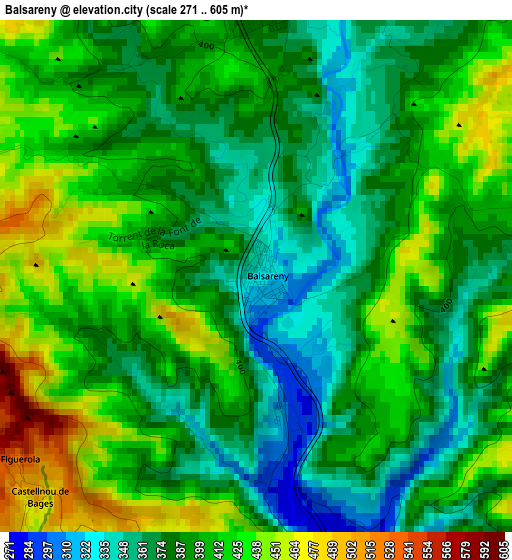
Below is the Elevation map of Balsareny, which displays elevation range with different colors. Scale of the first map is from 271 to 605 m (889 to 1985 ft) with average elevation of 396.4 meters (=1301 ft) [note 1]
These maps also provides idea of topography and contour of this city, they are displayed at different zoom levels. More info about maps, scale and edge coordinates you can find below images.
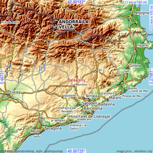
| \ | Map #1 | Topo.Map |
| Scale [m] | 271..605 m | × |
| Scale [ft] | 889..1985 ft | × |
| Average | 396.4 m = 1301 ft | × |
| Width | 7.28 km = 4.5 mi | 232.9 km = 144.7 mi |
| Height | 7.28 km = 4.5 mi | 232.9 km = 144.7 mi |
| ↑Max Latitude | 41.89583° | 42.90182° |
| Latitude at center | 41.86311° | 41.86311° |
| ↓Min Latitude | 41.830374° | 40.80725° |
| ← Min Longitude | 1.829615° | 0.46731° |
| Longitude center | 1.87356° | 1.87356° |
| →Max Longitude | 1.917505° | 3.27981° |
Nearby cities:
Cities around Balsareny sort by population:
• Sallent elevation 290 m
4.5 km,  156°
156°
• Súria 281 m
10.8 km,  252°
252°
• Navàs 376 m
4.1 km,  4°
4°
• Navarcles 256 m
12.6 km,  168°
168°
• Artés 317 m
9.9 km,  137°
137°
• Avinyó 369 m
8.1 km,  89°
89°
• Santa Maria d'Oló 498 m
13.2 km, 88°
• Sant Fruitós de Bages 250 m
12.6 km,  182°
182°
• Callús 261 m
11.7 km,  219°
219°
• Puig-reig 423 m
11.5 km, 4°
• Santpedor 315 m
9.2 km,  194°
194°
• Castellnou de Bages 484 m
4.4 km, 223°
Multilingual:
 En español:
Balsareny elevación 336 m.
 En France:
Balsareny élévation 336 m.
 Auf Deutsch:
Balsareny höhe über dem Meeresspiegel ist 336 m.

Sources and notes:
- [note 1] Map square and city borders are not equal. Map elevation data is calculated only from area inside that square.
- [src 1] Elevation data from geonames database provided with same terms of usage.
- [src 2] The elevation map of Balsareny is generated using elevation data from NASA's 3 arcsec (90m) resolution SRTM data.
- [src 3] Base (background) map © OpenStreetMap contributors tiles are generated by Geofabrik and OpenTopoMap.
Copyright & License:
This Balsareny Elevation Map is licensed under CC BY-SA. You may reuse any part from this page, if you give a proper credit by linking to this URL:
 More info on terms of use page.