Súria elevation
Súria (Catalonia, Província de Barcelona), Spain elevation is 281 meters and Súria elevation in feet is 922 ft above sea level [src 1]. Súria is a populated place (feature code) with elevation that is 322 meters (1056 ft) smaller than average city elevation in Spain.
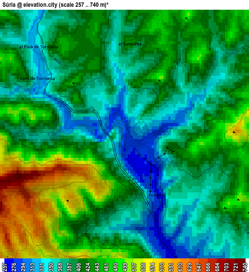
Below is the Elevation map of Súria, which displays elevation range with different colors. Scale of the first map is from 257 to 740 m (843 to 2428 ft) with average elevation of 415.9 meters (=1365 ft) [note 1]
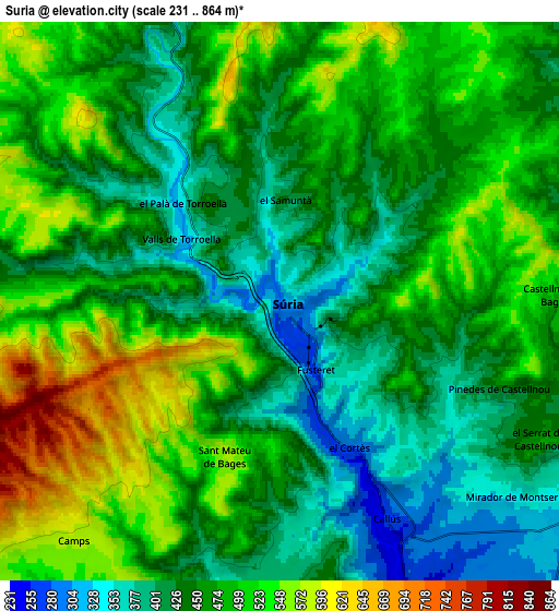
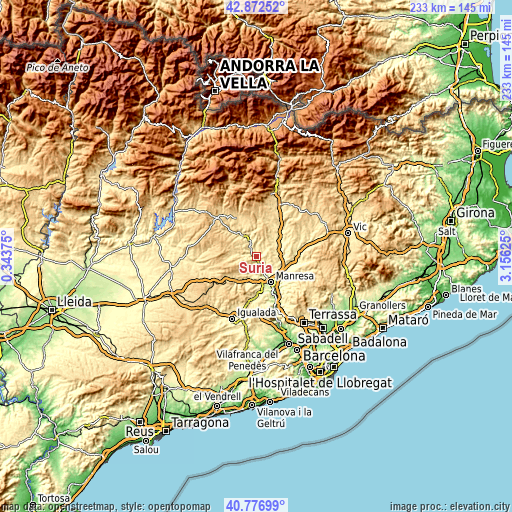
These maps also provides idea of topography and contour of this city, they are displayed at different zoom levels. More info about maps, scale and edge coordinates you can find below images.
| \ | Map #1 | Map #2 | Topo.Map |
| Scale [m] | 257..740 m | 231..864 m | × |
| Scale [ft] | 843..2428 ft | 758..2835 ft | × |
| Average | 415.9 m = 1365 ft | 467.1 m = 1532 ft | × |
| Width | 7.28 km = 4.5 mi | 14.56 km = 9 mi | 233 km = 144.8 mi |
| Height | 7.28 km = 4.5 mi | 14.56 km = 9 mi | 233 km = 144.8 mi |
| ↑Max Latitude | 41.866065° | 41.898783° | 42.87252° |
| Latitude at center | 41.83333° | 41.83333° | 41.83333° |
| ↓Min Latitude | 41.800578° | 41.76781° | 40.77699° |
| ← Min Longitude | 1.706055° | 1.662109° | 0.34375° |
| Longitude center | 1.75° | 1.75° | 1.75° |
| →Max Longitude | 1.793945° | 1.837891° | 3.15625° |
Nearby cities:
Cities around Súria sort by population:
• Manresa elevation 241 m
13.2 km,  152°
152°
• Sant Joan de Vilatorrada 230 m
10.8 km,  155°
155°
• Sallent 290 m
12.1 km,  93°
93°
• Navàs 376 m
12.9 km,  54°
54°
• Cardona 513 m
10.7 km,  326°
326°
• Balsareny 336 m
10.8 km,  72°
72°
• Fonollosa 529 m
10.3 km,  220°
220°
• Rajadell 358 m
12.3 km,  197°
197°
• Sant Fruitós de Bages 250 m
13.4 km,  133°
133°
• Santpedor 315 m
9.8 km,  124°
124°
• Castellnou de Bages 484 m
7.2 km, 89°
• Callús 261 m
6.4 km, 153°
Multilingual:
 En español:
Súria elevación 281 m.
 En France:
Súria élévation 281 m.


Sources and notes:
- [note 1] Map square and city borders are not equal. Map elevation data is calculated only from area inside that square.
- [src 1] Elevation data from geonames database provided with same terms of usage.
- [src 2] The elevation map of Súria is generated using elevation data from NASA's 3 arcsec (90m) resolution SRTM data.
- [src 3] Base (background) map © OpenStreetMap contributors tiles are generated by Geofabrik and OpenTopoMap.
Copyright & License:
This Súria Elevation Map is licensed under CC BY-SA. You may reuse any part from this page, if you give a proper credit by linking to this URL:
 More info on terms of use page.