Batea elevation
Batea (Catalonia, Província de Tarragona), Spain elevation is 365 meters and Batea elevation in feet is 1198 ft above sea level [src 1]. Batea is a seat of a third-order administrative division (feature code) with elevation that is 238 meters (781 ft) smaller than average city elevation in Spain.
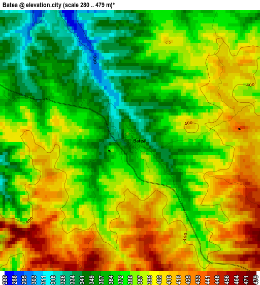
Below is the Elevation map of Batea, which displays elevation range with different colors. Scale of the first map is from 280 to 479 m (919 to 1572 ft) with average elevation of 382.4 meters (=1255 ft) [note 1]
These maps also provides idea of topography and contour of this city, they are displayed at different zoom levels. More info about maps, scale and edge coordinates you can find below images.
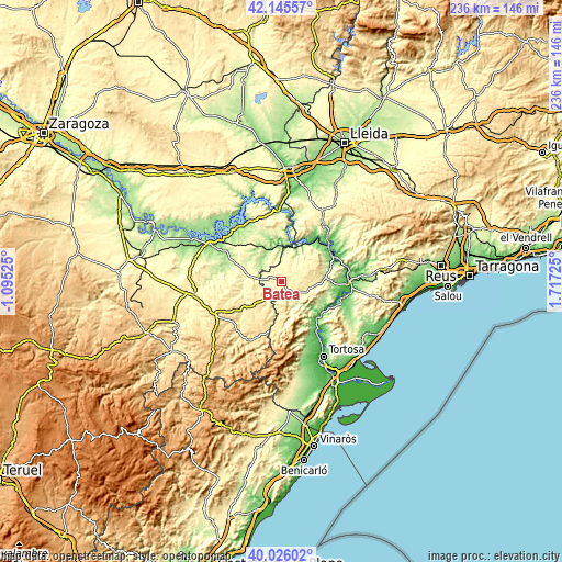
| \ | Map #1 | Topo.Map |
| Scale [m] | 280..479 m | × |
| Scale [ft] | 919..1572 ft | × |
| Average | 382.4 m = 1255 ft | × |
| Width | 7.36 km = 4.6 mi | 235.7 km = 146.5 mi |
| Height | 7.36 km = 4.6 mi | 235.7 km = 146.5 mi |
| ↑Max Latitude | 41.12745° | 42.14557° |
| Latitude at center | 41.09434° | 41.09434° |
| ↓Min Latitude | 41.061213° | 40.02602° |
| ← Min Longitude | 0.267055° | -1.09525° |
| Longitude center | 0.311° | 0.311° |
| →Max Longitude | 0.354945° | 1.71725° |
Nearby cities:
Cities around Batea sort by population:
• Gandesa elevation 374 m
11.6 km,  112°
112°
• Maella 302 m
14.7 km,  282°
282°
• Fabara 255 m
15.1 km,  307°
307°
• Calaceite 512 m
13.4 km,  229°
229°
• Nonaspe 182 m
13.8 km,  337°
337°
• Bot 294 m
11.3 km,  147°
147°
• Fayón 196 m
16.1 km,  6°
6°
• Arenys de Lledó / Arens de Lledó 378 m
11.8 km,  196°
196°
• Lledó 460 m
15.7 km,  190°
190°
• la Pobla de Massaluca 333 m
10.4 km,  18°
18°
• Vilalba dels Arcs 441 m
9.2 km,  74°
74°
• Caseres 344 m
8.5 km,  217°
217°
Multilingual:
 En español:
Batea elevación 365 m.
 En France:
Batea élévation 365 m.


Sources and notes:
- [note 1] Map square and city borders are not equal. Map elevation data is calculated only from area inside that square.
- [src 1] Elevation data from geonames database provided with same terms of usage.
- [src 2] The elevation map of Batea is generated using elevation data from NASA's 3 arcsec (90m) resolution SRTM data.
- [src 3] Base (background) map © OpenStreetMap contributors tiles are generated by Geofabrik and OpenTopoMap.
Copyright & License:
This Batea Elevation Map is licensed under CC BY-SA. You may reuse any part from this page, if you give a proper credit by linking to this URL:
 More info on terms of use page.