Béjar elevation
Béjar (Castille and León, Provincia de Salamanca), Spain elevation is 946 meters and Béjar elevation in feet is 3104 ft above sea level [src 1]. Béjar is a seat of a third-order administrative division (feature code) with elevation that is 343 meters (1125 ft) bigger than average city elevation in Spain.
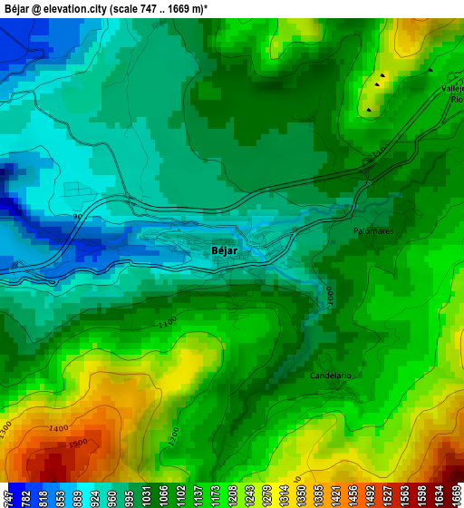
Below is the Elevation map of Béjar, which displays elevation range with different colors. Scale of the first map is from 747 to 1669 m (2451 to 5476 ft) with average elevation of 1086.5 meters (=3565 ft) [note 1]
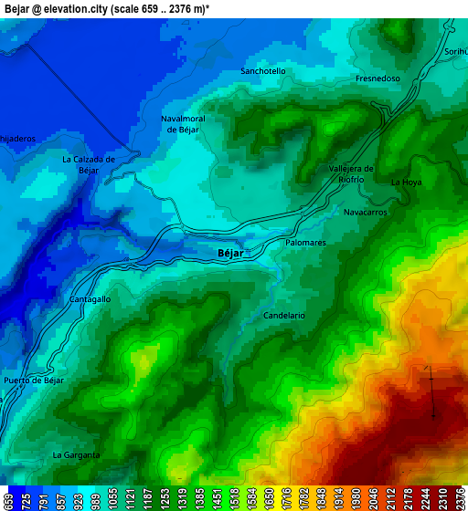
These maps also provides idea of topography and contour of this city, they are displayed at different zoom levels. More info about maps, scale and edge coordinates you can find below images.
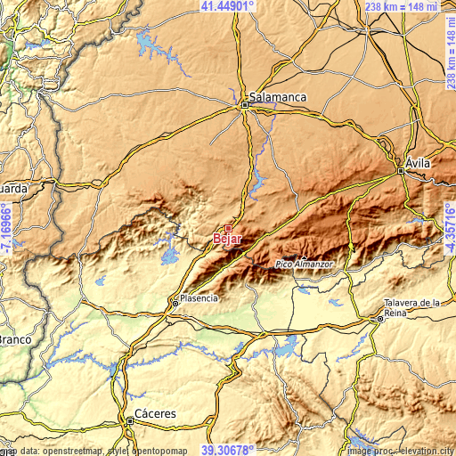
| \ | Map #1 | Map #2 | Topo.Map |
| Scale [m] | 747..1669 m | 659..2376 m | × |
| Scale [ft] | 2451..5476 ft | 2162..7795 ft | × |
| Average | 1086.5 m = 3565 ft | 1187.5 m = 3896 ft | × |
| Width | 7.44 km = 4.6 mi | 14.89 km = 9.3 mi | 238.2 km = 148 mi |
| Height | 7.44 km = 4.6 mi | 14.89 km = 9.3 mi | 238.2 km = 148 mi |
| ↑Max Latitude | 40.419874° | 40.453322° | 41.44901° |
| Latitude at center | 40.38641° | 40.38641° | 40.38641° |
| ↓Min Latitude | 40.352929° | 40.319431° | 39.30678° |
| ← Min Longitude | -5.807355° | -5.851301° | -7.16966° |
| Longitude center | -5.76341° | -5.76341° | -5.76341° |
| →Max Longitude | -5.719465° | -5.675519° | -4.35716° |
Nearby cities:
Cities around Béjar sort by population:
• Candelario elevation 1088 m
2.6 km,  142°
142°
• Puerto de Béjar 952 m
7.4 km,  237°
237°
• Sorihuela 1002 m
9.6 km,  48°
48°
• Sanchotello 944 m
5.8 km,  7°
7°
• Cantagallo 922 m
5 km,  251°
251°
• Peromingo 792 m
8.6 km,  354°
354°
• Navacarros 1127 m
4.4 km,  73°
73°
• Fresnedoso 1020 m
7.2 km,  39°
39°
• Valdehijaderos 779 m
8 km,  296°
296°
• Vallejera de Riofrío 1140 m
4.5 km,  55°
55°
• Navalmoral de Béjar 924 m
4.4 km,  337°
337°
• San Bartolomé de Béjar 1122 m
8.9 km, 74°
Multilingual:
 En español:
Béjar elevación 946 m.
 En France:
Béjar élévation 946 m.


Sources and notes:
- [note 1] Map square and city borders are not equal. Map elevation data is calculated only from area inside that square.
- [src 1] Elevation data from geonames database provided with same terms of usage.
- [src 2] The elevation map of Béjar is generated using elevation data from NASA's 3 arcsec (90m) resolution SRTM data.
- [src 3] Base (background) map © OpenStreetMap contributors tiles are generated by Geofabrik and OpenTopoMap.
Copyright & License:
This Béjar Elevation Map is licensed under CC BY-SA. You may reuse any part from this page, if you give a proper credit by linking to this URL:
 More info on terms of use page.