Cantagallo elevation
Cantagallo (Castille and León, Provincia de Salamanca), Spain elevation is 922 meters and Cantagallo elevation in feet is 3025 ft above sea level [src 1]. Cantagallo is a seat of a third-order administrative division (feature code) with elevation that is 319 meters (1047 ft) bigger than average city elevation in Spain.
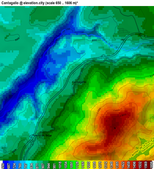
Below is the Elevation map of Cantagallo, which displays elevation range with different colors. Scale of the first map is from 650 to 1606 m (2133 to 5269 ft) with average elevation of 985.2 meters (=3232 ft) [note 1]
These maps also provides idea of topography and contour of this city, they are displayed at different zoom levels. More info about maps, scale and edge coordinates you can find below images.
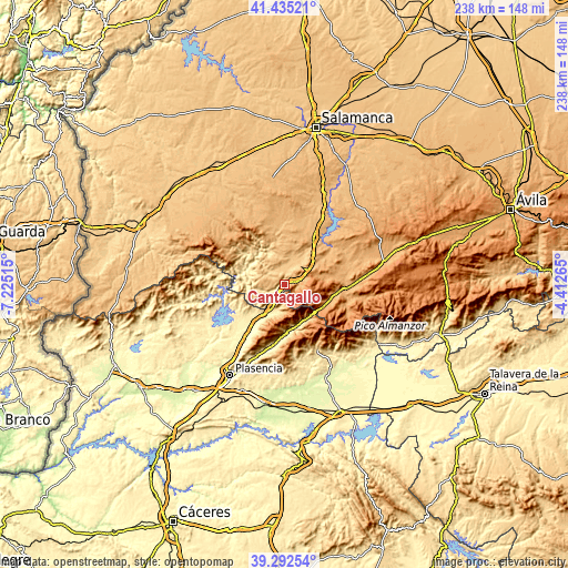
| \ | Map #1 | Topo.Map |
| Scale [m] | 650..1606 m | × |
| Scale [ft] | 2133..5269 ft | × |
| Average | 985.2 m = 3232 ft | × |
| Width | 7.45 km = 4.6 mi | 238.2 km = 148 mi |
| Height | 7.45 km = 4.6 mi | 238.2 km = 148 mi |
| ↑Max Latitude | 40.405861° | 41.43521° |
| Latitude at center | 40.37239° | 40.37239° |
| ↓Min Latitude | 40.338902° | 39.29254° |
| ← Min Longitude | -5.862845° | -7.22515° |
| Longitude center | -5.8189° | -5.8189° |
| →Max Longitude | -5.774955° | -4.41265° |
Nearby cities:
Cities around Cantagallo sort by population:
• Béjar elevation 946 m
5 km,  71°
71°
• Candelario 1088 m
6.3 km,  94°
94°
• Baños de Montemayor 696 m
7.1 km,  209°
209°
• Puerto de Béjar 952 m
2.9 km, 213°
• Montemayor del Río 659 m
6.9 km,  247°
247°
• Sanchotello 944 m
9.1 km,  36°
36°
• Horcajo de Montemayor 737 m
8.5 km,  311°
311°
• Aldeacipreste 876 m
6.7 km,  278°
278°
• Peñacaballera 875 m
4.8 km,  228°
228°
• Navacarros 1127 m
9.3 km, 72°
• Valdehijaderos 779 m
5.8 km,  334°
334°
• Navalmoral de Béjar 924 m
6.4 km,  28°
28°
Multilingual:
 En español:
Cantagallo elevación 922 m.
 En France:
Cantagallo élévation 922 m.
 Auf Deutsch:
Cantagallo höhe über dem Meeresspiegel ist 922 m.

Sources and notes:
- [note 1] Map square and city borders are not equal. Map elevation data is calculated only from area inside that square.
- [src 1] Elevation data from geonames database provided with same terms of usage.
- [src 2] The elevation map of Cantagallo is generated using elevation data from NASA's 3 arcsec (90m) resolution SRTM data.
- [src 3] Base (background) map © OpenStreetMap contributors tiles are generated by Geofabrik and OpenTopoMap.
Copyright & License:
This Cantagallo Elevation Map is licensed under CC BY-SA. You may reuse any part from this page, if you give a proper credit by linking to this URL:
 More info on terms of use page.