Belascoáin elevation
Belascoáin (Navarre, Provincia de Navarra), Spain elevation is 420 meters and Belascoáin elevation in feet is 1378 ft above sea level [src 1]. Belascoáin is a seat of a third-order administrative division (feature code) with elevation that is 183 meters (600 ft) smaller than average city elevation in Spain.
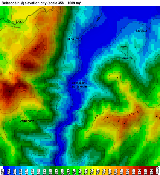
Below is the Elevation map of Belascoáin, which displays elevation range with different colors. Scale of the first map is from 358 to 1009 m (1175 to 3310 ft) with average elevation of 600.6 meters (=1970 ft) [note 1]
These maps also provides idea of topography and contour of this city, they are displayed at different zoom levels. More info about maps, scale and edge coordinates you can find below images.
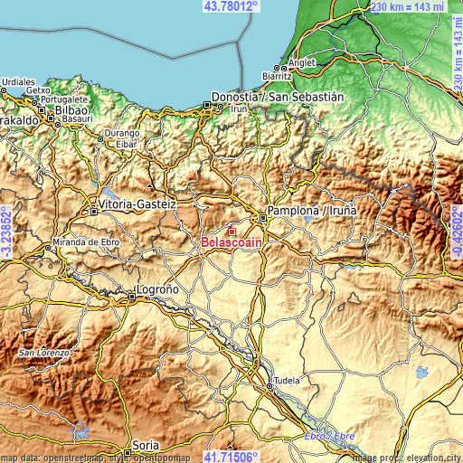
| \ | Map #1 | Topo.Map |
| Scale [m] | 358..1009 m | × |
| Scale [ft] | 1175..3310 ft | × |
| Average | 600.6 m = 1970 ft | × |
| Width | 7.18 km = 4.5 mi | 229.6 km = 142.7 mi |
| Height | 7.18 km = 4.5 mi | 229.6 km = 142.7 mi |
| ↑Max Latitude | 42.788448° | 43.78012° |
| Latitude at center | 42.75619° | 42.75619° |
| ↓Min Latitude | 42.723915° | 41.71506° |
| ← Min Longitude | -1.876215° | -3.23852° |
| Longitude center | -1.83227° | -1.83227° |
| →Max Longitude | -1.788325° | -0.42602° |
Nearby cities:
Cities around Belascoáin sort by population:
• Puente la Reina elevation 352 m
9.4 km,  170°
170°
• Obanos 416 m
9.2 km,  155°
155°
• Cirauqui 491 m
10.1 km,  208°
208°
• Mañeru 460 m
9.9 km,  194°
194°
• Muruzábal 447 m
8.9 km,  144°
144°
• Uterga 494 m
7.8 km,  131°
131°
• Legarda 477 m
7.2 km, 133°
• Salinas de Oro 683 m
5.1 km,  293°
293°
• Artazu 445 m
7.1 km,  184°
184°
• Guirguillano 616 m
5.7 km,  220°
220°
• Ciriza 467 m
3.8 km,  4°
4°
• Echarri 394 m
2.7 km,  12°
12°
Multilingual:
 En español:
Belascoáin elevación 420 m.
 En France:
Belascoáin élévation 420 m.
 Auf Deutsch:
Belascoáin höhe über dem Meeresspiegel ist 420 m.

Sources and notes:
- [note 1] Map square and city borders are not equal. Map elevation data is calculated only from area inside that square.
- [src 1] Elevation data from geonames database provided with same terms of usage.
- [src 2] The elevation map of Belascoáin is generated using elevation data from NASA's 3 arcsec (90m) resolution SRTM data.
- [src 3] Base (background) map © OpenStreetMap contributors tiles are generated by Geofabrik and OpenTopoMap.
Copyright & License:
This Belascoáin Elevation Map is licensed under CC BY-SA. You may reuse any part from this page, if you give a proper credit by linking to this URL:
 More info on terms of use page.