Belorado elevation
Belorado (Castille and León, Provincia de Burgos), Spain elevation is 770 meters and Belorado elevation in feet is 2526 ft above sea level [src 1]. Belorado is a seat of a third-order administrative division (feature code) with elevation that is 167 meters (548 ft) bigger than average city elevation in Spain.
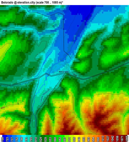
Below is the Elevation map of Belorado, which displays elevation range with different colors. Scale of the first map is from 708 to 1085 m (2323 to 3560 ft) with average elevation of 846.7 meters (=2778 ft) [note 1]
These maps also provides idea of topography and contour of this city, they are displayed at different zoom levels. More info about maps, scale and edge coordinates you can find below images.
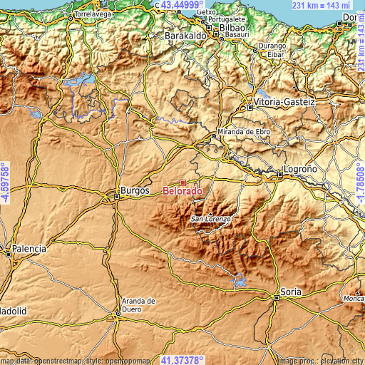
| \ | Map #1 | Topo.Map |
| Scale [m] | 708..1085 m | × |
| Scale [ft] | 2323..3560 ft | × |
| Average | 846.7 m = 2778 ft | × |
| Width | 7.21 km = 4.5 mi | 230.9 km = 143.5 mi |
| Height | 7.21 km = 4.5 mi | 230.8 km = 143.4 mi |
| ↑Max Latitude | 42.452913° | 43.44999° |
| Latitude at center | 42.42048° | 42.42048° |
| ↓Min Latitude | 42.388031° | 41.37378° |
| ← Min Longitude | -3.235275° | -4.59758° |
| Longitude center | -3.19133° | -3.19133° |
| →Max Longitude | -3.147385° | -1.78508° |
Nearby cities:
Cities around Belorado sort by population:
• Fresneña elevation 853 m
4.7 km,  99°
99°
• Ibrillos 741 m
9.7 km,  67°
67°
• Villagalijo 899 m
8 km,  180°
180°
• Redecilla del Campo 745 m
8.1 km,  50°
50°
• Castildelgado 768 m
9 km,  77°
77°
• Tosantos 821 m
4.3 km,  259°
259°
• San Vicente del Valle 959 m
9.5 km,  165°
165°
• Bascuñana 800 m
9 km,  86°
86°
• Viloria de Rioja 799 m
7.5 km, 85°
• Carrias 821 m
10.1 km,  311°
311°
• Espinosa del Camino 895 m
7.5 km, 257°
• Cerezo de Río Tirón 661 m
9.1 km,  29°
29°
Multilingual:
 En español:
Belorado elevación 770 m.
 En France:
Belorado élévation 770 m.
 Auf Deutsch:
Belorado höhe über dem Meeresspiegel ist 770 m.

Sources and notes:
- [note 1] Map square and city borders are not equal. Map elevation data is calculated only from area inside that square.
- [src 1] Elevation data from geonames database provided with same terms of usage.
- [src 2] The elevation map of Belorado is generated using elevation data from NASA's 3 arcsec (90m) resolution SRTM data.
- [src 3] Base (background) map © OpenStreetMap contributors tiles are generated by Geofabrik and OpenTopoMap.
Copyright & License:
This Belorado Elevation Map is licensed under CC BY-SA. You may reuse any part from this page, if you give a proper credit by linking to this URL:
 More info on terms of use page.