Tosantos elevation
Tosantos (Castille and León, Provincia de Burgos), Spain elevation is 821 meters and Tosantos elevation in feet is 2694 ft above sea level [src 1]. Tosantos is a seat of a third-order administrative division (feature code) with elevation that is 218 meters (715 ft) bigger than average city elevation in Spain.
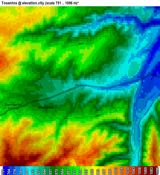
Below is the Elevation map of Tosantos, which displays elevation range with different colors. Scale of the first map is from 751 to 1096 m (2464 to 3596 ft) with average elevation of 892.8 meters (=2929 ft) [note 1]
These maps also provides idea of topography and contour of this city, they are displayed at different zoom levels. More info about maps, scale and edge coordinates you can find below images.
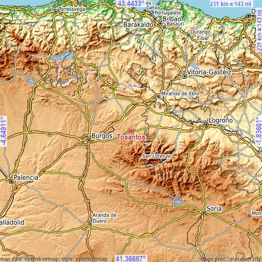
| \ | Map #1 | Topo.Map |
| Scale [m] | 751..1096 m | × |
| Scale [ft] | 2464..3596 ft | × |
| Average | 892.8 m = 2929 ft | × |
| Width | 7.21 km = 4.5 mi | 230.9 km = 143.5 mi |
| Height | 7.21 km = 4.5 mi | 230.9 km = 143.5 mi |
| ↑Max Latitude | 42.446116° | 43.4433° |
| Latitude at center | 42.41368° | 42.41368° |
| ↓Min Latitude | 42.381227° | 41.36687° |
| ← Min Longitude | -3.286805° | -4.64911° |
| Longitude center | -3.24286° | -3.24286° |
| →Max Longitude | -3.198915° | -1.83661° |
Nearby cities:
Cities around Tosantos sort by population:
• Belorado elevation 770 m
4.3 km,  79°
79°
• Pradoluengo 958 m
10.4 km,  161°
161°
• Rábanos 1171 m
10.7 km,  192°
192°
• Fresneña 853 m
8.9 km,  90°
90°
• Villagalijo 899 m
8.3 km,  149°
149°
• Viloria de Rioja 799 m
11.8 km, 83°
• San Vicente del Valle 959 m
10.8 km,  141°
141°
• Cerratón de Juarros 954 m
10.8 km,  275°
275°
• Alcocero de Mola 800 m
11.5 km,  304°
304°
• Bañuelos de Bureba 775 m
10.3 km,  343°
343°
• Carrias 821 m
8.2 km, 336°
• Espinosa del Camino 895 m
3.2 km,  254°
254°
Multilingual:
 En español:
Tosantos elevación 821 m.
 En France:
Tosantos élévation 821 m.
 Auf Deutsch:
Tosantos höhe über dem Meeresspiegel ist 821 m.

Sources and notes:
- [note 1] Map square and city borders are not equal. Map elevation data is calculated only from area inside that square.
- [src 1] Elevation data from geonames database provided with same terms of usage.
- [src 2] The elevation map of Tosantos is generated using elevation data from NASA's 3 arcsec (90m) resolution SRTM data.
- [src 3] Base (background) map © OpenStreetMap contributors tiles are generated by Geofabrik and OpenTopoMap.
Copyright & License:
This Tosantos Elevation Map is licensed under CC BY-SA. You may reuse any part from this page, if you give a proper credit by linking to this URL:
 More info on terms of use page.