Biota elevation
Biota (Aragon, Provincia de Zaragoza), Spain elevation is 493 meters and Biota elevation in feet is 1617 ft above sea level [src 1]. Biota is a seat of a third-order administrative division (feature code) with elevation that is 110 meters (361 ft) smaller than average city elevation in Spain.
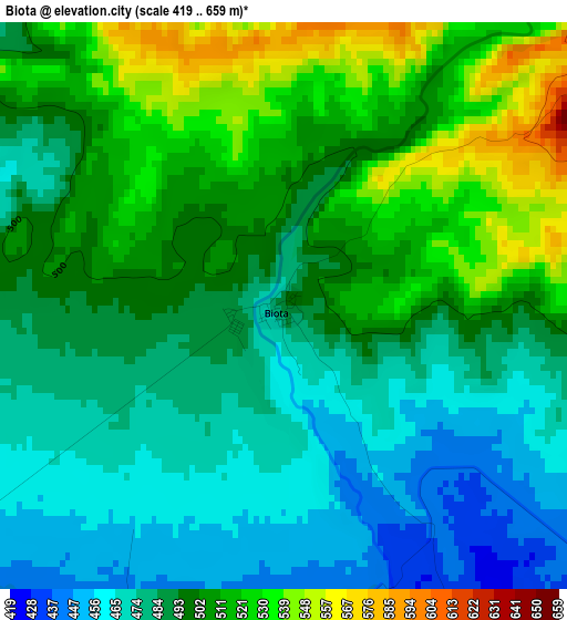
Below is the Elevation map of Biota, which displays elevation range with different colors. Scale of the first map is from 419 to 659 m (1375 to 2162 ft) with average elevation of 495 meters (=1624 ft) [note 1]
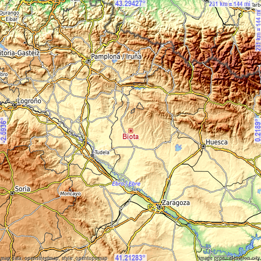
These maps also provides idea of topography and contour of this city, they are displayed at different zoom levels. More info about maps, scale and edge coordinates you can find below images.
| \ | Map #1 | Topo.Map |
| Scale [m] | 419..659 m | × |
| Scale [ft] | 1375..2162 ft | × |
| Average | 495 m = 1624 ft | × |
| Width | 7.23 km = 4.5 mi | 231.4 km = 143.8 mi |
| Height | 7.23 km = 4.5 mi | 231.4 km = 143.8 mi |
| ↑Max Latitude | 42.294654° | 43.29427° |
| Latitude at center | 42.26214° | 42.26214° |
| ↓Min Latitude | 42.229609° | 41.21283° |
| ← Min Longitude | -1.231295° | -2.5936° |
| Longitude center | -1.18735° | -1.18735° |
| →Max Longitude | -1.143405° | 0.2189° |
Nearby cities:
Cities around Biota sort by population:
• Ejea de los Caballeros elevation 327 m
15.7 km,  164°
164°
• Carcastillo 354 m
24.8 km,  301°
301°
• Sádaba 447 m
7.1 km,  287°
287°
• Luna 474 m
23.4 km,  116°
116°
• Uncastillo 614 m
11.9 km,  24°
24°
• Castiliscar 491 m
14.6 km,  330°
330°
• Luesia 794 m
18 km,  48°
48°
• Biel 766 m
24.6 km,  55°
55°
• Layana 481 m
6 km,  308°
308°
• Orés 631 m
15.4 km,  83°
83°
• Petilla de Aragón 935 m
21.7 km, 15°
• Asin 631 m
11.8 km, 78°
Multilingual:
 En español:
Biota elevación 493 m.
 En France:
Biota élévation 493 m.


Sources and notes:
- [note 1] Map square and city borders are not equal. Map elevation data is calculated only from area inside that square.
- [src 1] Elevation data from geonames database provided with same terms of usage.
- [src 2] The elevation map of Biota is generated using elevation data from NASA's 3 arcsec (90m) resolution SRTM data.
- [src 3] Base (background) map © OpenStreetMap contributors tiles are generated by Geofabrik and OpenTopoMap.
Copyright & License:
This Biota Elevation Map is licensed under CC BY-SA. You may reuse any part from this page, if you give a proper credit by linking to this URL:
 More info on terms of use page.