Buenaventura elevation
Buenaventura (Castille-La Mancha, Province of Toledo), Spain elevation is 432 meters and Buenaventura elevation in feet is 1417 ft above sea level [src 1]. Buenaventura is a seat of a third-order administrative division (feature code) with elevation that is 171 meters (561 ft) smaller than average city elevation in Spain.
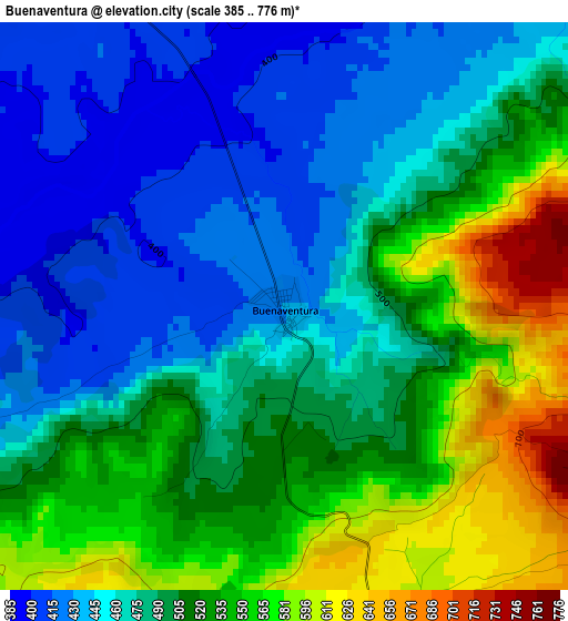
Below is the Elevation map of Buenaventura, which displays elevation range with different colors. Scale of the first map is from 385 to 776 m (1263 to 2546 ft) with average elevation of 497.2 meters (=1631 ft) [note 1]
These maps also provides idea of topography and contour of this city, they are displayed at different zoom levels. More info about maps, scale and edge coordinates you can find below images.
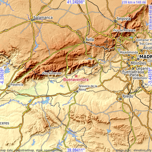
| \ | Map #1 | Topo.Map |
| Scale [m] | 385..776 m | × |
| Scale [ft] | 1263..2546 ft | × |
| Average | 497.2 m = 1631 ft | × |
| Width | 7.47 km = 4.6 mi | 238.9 km = 148.4 mi |
| Height | 7.47 km = 4.6 mi | 238.9 km = 148.4 mi |
| ↑Max Latitude | 40.210618° | 41.24298° |
| Latitude at center | 40.17705° | 40.17705° |
| ↓Min Latitude | 40.143465° | 39.09411° |
| ← Min Longitude | -4.893975° | -6.25628° |
| Longitude center | -4.85003° | -4.85003° |
| →Max Longitude | -4.806085° | -3.44378° |
Nearby cities:
Cities around Buenaventura sort by population:
• Casavieja elevation 576 m
13.8 km,  30°
30°
• Pedro Bernardo 788 m
8.8 km,  325°
325°
• El Real de San Vicente 751 m
14.3 km,  108°
108°
• Mijares 851 m
13.3 km,  4°
4°
• Navamorcuende 772 m
5.9 km, 112°
• Gavilanes 685 m
11.2 km,  358°
358°
• Hinojosa de San Vicente 656 m
13.5 km,  126°
126°
• Montesclaros 559 m
10.9 km,  223°
223°
• Almendral de la Cañada 636 m
9.2 km,  84°
84°
• Cervera de los Montes 535 m
14.3 km,  166°
166°
• Sotillo de las Palomas 563 m
8.4 km, 166°
• Sartajada 457 m
6.2 km,  49°
49°
Multilingual:
 En español:
Buenaventura elevación 432 m.
 En France:
Buenaventura élévation 432 m.
 Auf Deutsch:
Buenaventura höhe über dem Meeresspiegel ist 432 m.

Sources and notes:
- [note 1] Map square and city borders are not equal. Map elevation data is calculated only from area inside that square.
- [src 1] Elevation data from geonames database provided with same terms of usage.
- [src 2] The elevation map of Buenaventura is generated using elevation data from NASA's 3 arcsec (90m) resolution SRTM data.
- [src 3] Base (background) map © OpenStreetMap contributors tiles are generated by Geofabrik and OpenTopoMap.
Copyright & License:
This Buenaventura Elevation Map is licensed under CC BY-SA. You may reuse any part from this page, if you give a proper credit by linking to this URL:
 More info on terms of use page.