Mijares elevation
Mijares (Castille and León, Provincia de Ávila), Spain elevation is 851 meters and Mijares elevation in feet is 2792 ft above sea level [src 1]. Mijares is a seat of a third-order administrative division (feature code) with elevation that is 248 meters (814 ft) bigger than average city elevation in Spain.
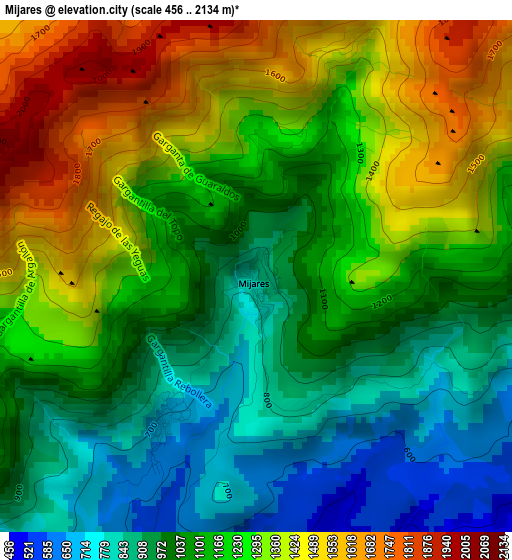
Below is the Elevation map of Mijares, which displays elevation range with different colors. Scale of the first map is from 456 to 2134 m (1496 to 7001 ft) with average elevation of 1155.5 meters (=3791 ft) [note 1]
These maps also provides idea of topography and contour of this city, they are displayed at different zoom levels. More info about maps, scale and edge coordinates you can find below images.
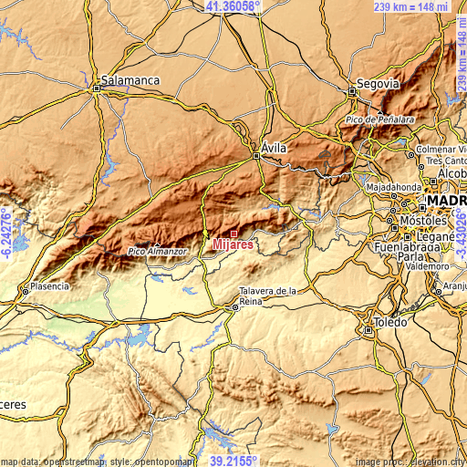
| \ | Map #1 | Topo.Map |
| Scale [m] | 456..2134 m | × |
| Scale [ft] | 1496..7001 ft | × |
| Average | 1155.5 m = 3791 ft | × |
| Width | 7.45 km = 4.6 mi | 238.5 km = 148.2 mi |
| Height | 7.45 km = 4.6 mi | 238.5 km = 148.2 mi |
| ↑Max Latitude | 40.330059° | 41.36058° |
| Latitude at center | 40.29655° | 40.29655° |
| ↓Min Latitude | 40.263024° | 39.2155° |
| ← Min Longitude | -4.880455° | -6.24276° |
| Longitude center | -4.83651° | -4.83651° |
| →Max Longitude | -4.792565° | -3.43026° |
Nearby cities:
Cities around Mijares sort by population:
• Piedralaves elevation 715 m
11.8 km,  78°
78°
• Casavieja 576 m
6.1 km,  104°
104°
• Pedro Bernardo 788 m
8.7 km,  225°
225°
• Burgohondo 847 m
13.8 km,  18°
18°
• San Esteban del Valle 776 m
12.6 km,  259°
259°
• Gavilanes 685 m
2.5 km,  214°
214°
• Buenaventura 432 m
13.3 km,  184°
184°
• Villarejo del Valle 841 m
13.6 km,  265°
265°
• Navarrevisca 1136 m
8.9 km,  327°
327°
• Serranillos 1224 m
7.8 km,  304°
304°
• Navatalgordo 1268 m
13.5 km,  347°
347°
• Sartajada 457 m
9.9 km,  158°
158°
Multilingual:
 En español:
Mijares elevación 851 m.
 En France:
Mijares élévation 851 m.


Sources and notes:
- [note 1] Map square and city borders are not equal. Map elevation data is calculated only from area inside that square.
- [src 1] Elevation data from geonames database provided with same terms of usage.
- [src 2] The elevation map of Mijares is generated using elevation data from NASA's 3 arcsec (90m) resolution SRTM data.
- [src 3] Base (background) map © OpenStreetMap contributors tiles are generated by Geofabrik and OpenTopoMap.
Copyright & License:
This Mijares Elevation Map is licensed under CC BY-SA. You may reuse any part from this page, if you give a proper credit by linking to this URL:
 More info on terms of use page.