Buendía elevation
Buendía (Castille-La Mancha, Provincia de Cuenca), Spain elevation is 744 meters and Buendía elevation in feet is 2441 ft above sea level [src 1]. Buendía is a seat of a third-order administrative division (feature code) with elevation that is 141 meters (463 ft) bigger than average city elevation in Spain.
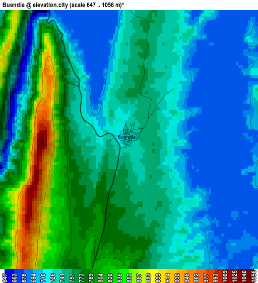
Below is the Elevation map of Buendía, which displays elevation range with different colors. Scale of the first map is from 647 to 1056 m (2123 to 3465 ft) with average elevation of 752.9 meters (=2470 ft) [note 1]
These maps also provides idea of topography and contour of this city, they are displayed at different zoom levels. More info about maps, scale and edge coordinates you can find below images.
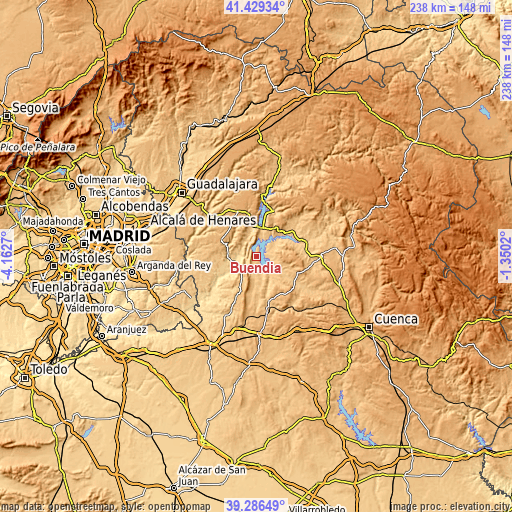
| \ | Map #1 | Topo.Map |
| Scale [m] | 647..1056 m | × |
| Scale [ft] | 2123..3465 ft | × |
| Average | 752.9 m = 2470 ft | × |
| Width | 7.45 km = 4.6 mi | 238.3 km = 148.1 mi |
| Height | 7.45 km = 4.6 mi | 238.3 km = 148.1 mi |
| ↑Max Latitude | 40.399904° | 41.42934° |
| Latitude at center | 40.36643° | 40.36643° |
| ↓Min Latitude | 40.332939° | 39.28649° |
| ← Min Longitude | -2.800395° | -4.1627° |
| Longitude center | -2.75645° | -2.75645° |
| →Max Longitude | -2.712505° | -1.3502° |
Nearby cities:
Cities around Buendía sort by population:
• Sacedón elevation 747 m
12.9 km,  8°
8°
• Pastrana 778 m
15.2 km,  292°
292°
• Almonacid de Zorita 703 m
9 km,  242°
242°
• Albalate de Zorita 771 m
9.8 km,  228°
228°
• Villalba del Rey 798 m
10.2 km,  102°
102°
• Tinajas 870 m
15.4 km,  107°
107°
• Alcocer 789 m
16.9 km,  47°
47°
• Cañaveruelas 797 m
10.8 km,  69°
69°
• Sayatón 661 m
8.2 km,  277°
277°
• Zorita de los Canes 612 m
11.8 km,  250°
250°
• Alcohujate 814 m
13.3 km,  64°
64°
• Valdeconcha 734 m
14.3 km,  314°
314°
Multilingual:
 En español:
Buendía elevación 744 m.
 En France:
Buendía élévation 744 m.


Sources and notes:
- [note 1] Map square and city borders are not equal. Map elevation data is calculated only from area inside that square.
- [src 1] Elevation data from geonames database provided with same terms of usage.
- [src 2] The elevation map of Buendía is generated using elevation data from NASA's 3 arcsec (90m) resolution SRTM data.
- [src 3] Base (background) map © OpenStreetMap contributors tiles are generated by Geofabrik and OpenTopoMap.
Copyright & License:
This Buendía Elevation Map is licensed under CC BY-SA. You may reuse any part from this page, if you give a proper credit by linking to this URL:
 More info on terms of use page.