Alcocer elevation
Alcocer (Castille-La Mancha, Provincia de Guadalajara), Spain elevation is 789 meters and Alcocer elevation in feet is 2589 ft above sea level [src 1]. Alcocer is a seat of a third-order administrative division (feature code) with elevation that is 186 meters (610 ft) bigger than average city elevation in Spain.
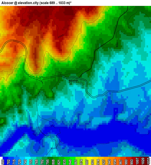
Below is the Elevation map of Alcocer, which displays elevation range with different colors. Scale of the first map is from 689 to 1033 m (2260 to 3389 ft) with average elevation of 803.5 meters (=2636 ft) [note 1]
These maps also provides idea of topography and contour of this city, they are displayed at different zoom levels. More info about maps, scale and edge coordinates you can find below images.
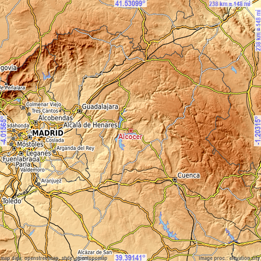
| \ | Map #1 | Topo.Map |
| Scale [m] | 689..1033 m | × |
| Scale [ft] | 2260..3389 ft | × |
| Average | 803.5 m = 2636 ft | × |
| Width | 7.43 km = 4.6 mi | 237.9 km = 147.8 mi |
| Height | 7.43 km = 4.6 mi | 237.9 km = 147.8 mi |
| ↑Max Latitude | 40.503143° | 41.53099° |
| Latitude at center | 40.46972° | 40.46972° |
| ↓Min Latitude | 40.43628° | 39.39141° |
| ← Min Longitude | -2.653345° | -4.01565° |
| Longitude center | -2.6094° | -2.6094° |
| →Max Longitude | -2.565455° | -1.20315° |
Nearby cities:
Cities around Alcocer sort by population:
• Sacedón elevation 747 m
10.6 km,  276°
276°
• Villalba del Rey 798 m
13.9 km,  190°
190°
• Pareja 768 m
10.1 km,  340°
340°
• Canalejas del Arroyo 795 m
14.9 km,  139°
139°
• Valdeolivas 929 m
14.4 km,  73°
73°
• Salmerón 831 m
12.9 km,  49°
49°
• Cañaveruelas 797 m
8.1 km,  196°
196°
• Millana 819 m
5.3 km,  37°
37°
• Escamilla 1034 m
9.7 km,  23°
23°
• Alcohujate 814 m
5.8 km,  184°
184°
• Villar del Infantado 769 m
11.1 km,  98°
98°
• Alique 926 m
13.3 km,  347°
347°
Multilingual:
 En español:
Alcocer elevación 789 m.
 En France:
Alcocer élévation 789 m.


Sources and notes:
- [note 1] Map square and city borders are not equal. Map elevation data is calculated only from area inside that square.
- [src 1] Elevation data from geonames database provided with same terms of usage.
- [src 2] The elevation map of Alcocer is generated using elevation data from NASA's 3 arcsec (90m) resolution SRTM data.
- [src 3] Base (background) map © OpenStreetMap contributors tiles are generated by Geofabrik and OpenTopoMap.
Copyright & License:
This Alcocer Elevation Map is licensed under CC BY-SA. You may reuse any part from this page, if you give a proper credit by linking to this URL:
 More info on terms of use page.