Calatayud elevation
Calatayud (Aragon, Provincia de Zaragoza), Spain elevation is 542 meters and Calatayud elevation in feet is 1778 ft above sea level [src 1]. Calatayud is a seat of a third-order administrative division (feature code) with elevation that is 61 meters (200 ft) smaller than average city elevation in Spain.
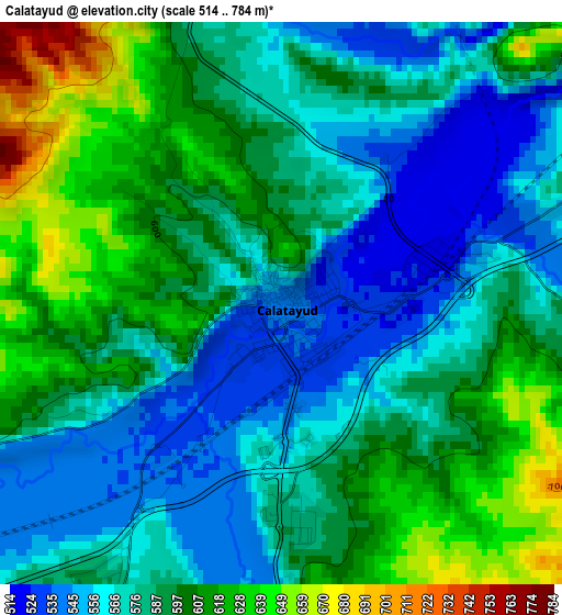
Below is the Elevation map of Calatayud, which displays elevation range with different colors. Scale of the first map is from 514 to 784 m (1686 to 2572 ft) with average elevation of 587 meters (=1926 ft) [note 1]
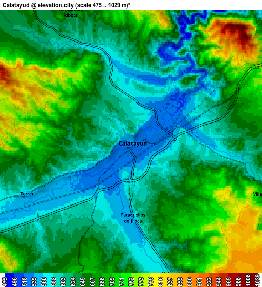
These maps also provides idea of topography and contour of this city, they are displayed at different zoom levels. More info about maps, scale and edge coordinates you can find below images.
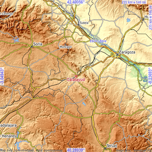
| \ | Map #1 | Map #2 | Topo.Map |
| Scale [m] | 514..784 m | 475..1029 m | × |
| Scale [ft] | 1686..2572 ft | 1558..3376 ft | × |
| Average | 587 m = 1926 ft | 654.3 m = 2147 ft | × |
| Width | 7.34 km = 4.6 mi | 14.67 km = 9.1 mi | 234.7 km = 145.8 mi |
| Height | 7.34 km = 4.6 mi | 14.67 km = 9.1 mi | 234.7 km = 145.8 mi |
| ↑Max Latitude | 41.386509° | 41.419471° | 42.40056° |
| Latitude at center | 41.35353° | 41.35353° | 41.35353° |
| ↓Min Latitude | 41.320534° | 41.287522° | 40.28939° |
| ← Min Longitude | -1.687125° | -1.731071° | -3.04943° |
| Longitude center | -1.64318° | -1.64318° | -1.64318° |
| →Max Longitude | -1.599235° | -1.555289° | -0.23693° |
Nearby cities:
Cities around Calatayud sort by population:
• Maluenda elevation 588 m
7.7 km,  162°
162°
• Terrer 567 m
6.5 km,  244°
244°
• Paracuellos de Jiloca 568 m
4.4 km,  176°
176°
• Munébrega 749 m
12.4 km,  204°
204°
• Cervera de la Cañada 692 m
11.7 km,  318°
318°
• Paracuellos de la Ribera 499 m
10.2 km,  41°
41°
• Mara 697 m
12.6 km,  124°
124°
• Torralba de Ribota 653 m
7.9 km,  334°
334°
• Villalba de Perejil 621 m
8.4 km,  110°
110°
• Valtorres 673 m
10.2 km,  233°
233°
• Velilla de Jiloca 615 m
9.3 km, 159°
• Sediles 731 m
9.3 km,  95°
95°
Multilingual:
 En español:
Calatayud elevación 542 m.
 En France:
Calatayud élévation 542 m.
 Auf Deutsch:
Calatayud höhe über dem Meeresspiegel ist 542 m.

Sources and notes:
- [note 1] Map square and city borders are not equal. Map elevation data is calculated only from area inside that square.
- [src 1] Elevation data from geonames database provided with same terms of usage.
- [src 2] The elevation map of Calatayud is generated using elevation data from NASA's 3 arcsec (90m) resolution SRTM data.
- [src 3] Base (background) map © OpenStreetMap contributors tiles are generated by Geofabrik and OpenTopoMap.
Copyright & License:
This Calatayud Elevation Map is licensed under CC BY-SA. You may reuse any part from this page, if you give a proper credit by linking to this URL:
 More info on terms of use page.