Maluenda elevation
Maluenda (Aragon, Provincia de Zaragoza), Spain elevation is 588 meters and Maluenda elevation in feet is 1929 ft above sea level [src 1]. Maluenda is a seat of a third-order administrative division (feature code) with elevation that is 15 meters (49 ft) smaller than average city elevation in Spain.
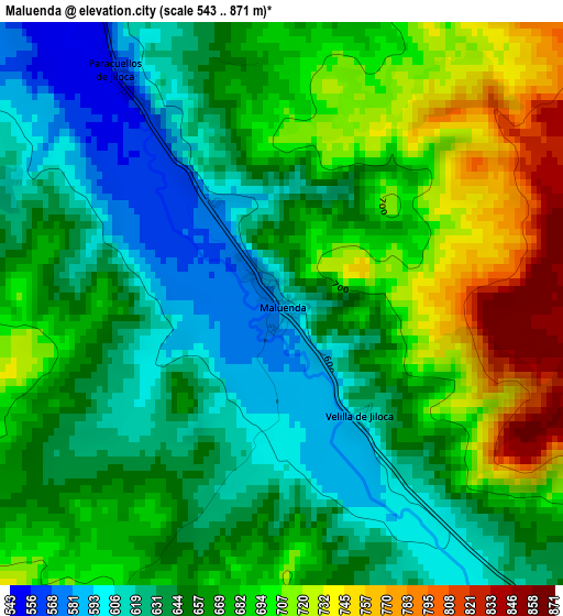
Below is the Elevation map of Maluenda, which displays elevation range with different colors. Scale of the first map is from 543 to 871 m (1781 to 2858 ft) with average elevation of 664.3 meters (=2179 ft) [note 1]
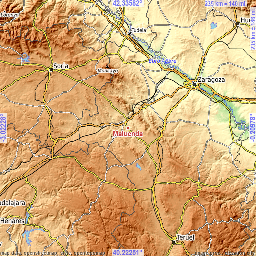
These maps also provides idea of topography and contour of this city, they are displayed at different zoom levels. More info about maps, scale and edge coordinates you can find below images.
| \ | Map #1 | Topo.Map |
| Scale [m] | 543..871 m | × |
| Scale [ft] | 1781..2858 ft | × |
| Average | 664.3 m = 2179 ft | × |
| Width | 7.34 km = 4.6 mi | 235 km = 146 mi |
| Height | 7.34 km = 4.6 mi | 235 km = 146 mi |
| ↑Max Latitude | 41.320732° | 42.33582° |
| Latitude at center | 41.28772° | 41.28772° |
| ↓Min Latitude | 41.254691° | 40.22251° |
| ← Min Longitude | -1.659975° | -3.02228° |
| Longitude center | -1.61603° | -1.61603° |
| →Max Longitude | -1.572085° | -0.20978° |
Nearby cities:
Cities around Maluenda sort by population:
• Calatayud elevation 542 m
7.7 km,  342°
342°
• Terrer 567 m
9.3 km,  298°
298°
• Paracuellos de Jiloca 568 m
3.5 km,  325°
325°
• Munébrega 749 m
8.5 km,  242°
242°
• Fuentes de Jiloca 693 m
9.4 km,  134°
134°
• Morata de Jiloca 620 m
5.1 km,  150°
150°
• Mara 697 m
8.2 km,  88°
88°
• Alarba 852 m
9.2 km,  178°
178°
• Villalba de Perejil 621 m
7.2 km,  52°
52°
• Olvés 795 m
5.9 km,  205°
205°
• Velilla de Jiloca 615 m
1.7 km,  144°
144°
• Sediles 731 m
9.6 km, 47°
Multilingual:
 En español:
Maluenda elevación 588 m.
 En France:
Maluenda élévation 588 m.
 Auf Deutsch:
Maluenda höhe über dem Meeresspiegel ist 588 m.

Sources and notes:
- [note 1] Map square and city borders are not equal. Map elevation data is calculated only from area inside that square.
- [src 1] Elevation data from geonames database provided with same terms of usage.
- [src 2] The elevation map of Maluenda is generated using elevation data from NASA's 3 arcsec (90m) resolution SRTM data.
- [src 3] Base (background) map © OpenStreetMap contributors tiles are generated by Geofabrik and OpenTopoMap.
Copyright & License:
This Maluenda Elevation Map is licensed under CC BY-SA. You may reuse any part from this page, if you give a proper credit by linking to this URL:
 More info on terms of use page.