Calella elevation
Calella (Catalonia, Província de Barcelona), Spain elevation is 15 meters and Calella elevation in feet is 49 ft above sea level [src 1]. Calella is a seat of a third-order administrative division (feature code) with elevation that is 588 meters (1929 ft) smaller than average city elevation in Spain.
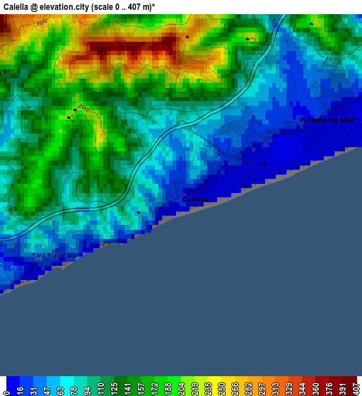
Below is the Elevation map of Calella, which displays elevation range with different colors. Scale of the first map is from 0 to 407 m (0 to 1335 ft) with average elevation of 118.1 meters (=387 ft) [note 1]
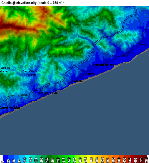
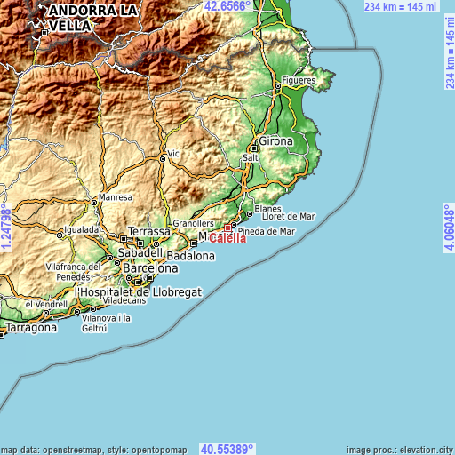
These maps also provides idea of topography and contour of this city, they are displayed at different zoom levels. More info about maps, scale and edge coordinates you can find below images.
| \ | Map #1 | Map #2 | Topo.Map |
| Scale [m] | 0..407 m | 0..754 m | × |
| Scale [ft] | 0..1335 ft | 0..2474 ft | × |
| Average | 118.1 m = 387 ft | 189.8 m = 623 ft | × |
| Width | 7.31 km = 4.5 mi | 14.61 km = 9.1 mi | 233.8 km = 145.3 mi |
| Height | 7.31 km = 4.5 mi | 14.61 km = 9.1 mi | 233.8 km = 145.3 mi |
| ↑Max Latitude | 41.646657° | 41.679487° | 42.6566° |
| Latitude at center | 41.61381° | 41.61381° | 41.61381° |
| ↓Min Latitude | 41.580946° | 41.548066° | 40.55389° |
| ← Min Longitude | 2.610285° | 2.566339° | 1.24798° |
| Longitude center | 2.65423° | 2.65423° | 2.65423° |
| →Max Longitude | 2.698175° | 2.742121° | 4.06048° |
Nearby cities:
Cities around Calella sort by population:
• Pineda de Mar elevation 12 m
3.3 km,  61°
61°
• Malgrat de Mar 9 m
8.1 km, 63°
• Tordera 41 m
10.9 km,  29°
29°
• Arenys de Mar 25 m
9.4 km,  247°
247°
• Canet de Mar 31 m
6.6 km, 246°
• Arenys de Munt 149 m
9.5 km,  270°
270°
• Sant Pol de Mar 29 m
3.3 km, 246°
• Santa Susanna 4 m
5.6 km,  67°
67°
• Vallgorguina 222 m
12.6 km,  287°
287°
• Caldes d'Estrac 1 m
11.3 km,  242°
242°
• Palafolls 22 m
9.9 km,  53°
53°
• Sant Iscle de Vallalta 247 m
7.3 km, 272°
Multilingual:
 En español:
Calella elevación 15 m.
 En France:
Calella élévation 15 m.


Sources and notes:
- [note 1] Map square and city borders are not equal. Map elevation data is calculated only from area inside that square.
- [src 1] Elevation data from geonames database provided with same terms of usage.
- [src 2] The elevation map of Calella is generated using elevation data from NASA's 3 arcsec (90m) resolution SRTM data.
- [src 3] Base (background) map © OpenStreetMap contributors tiles are generated by Geofabrik and OpenTopoMap.
Copyright & License:
This Calella Elevation Map is licensed under CC BY-SA. You may reuse any part from this page, if you give a proper credit by linking to this URL:
 More info on terms of use page.