Malgrat de Mar elevation
Malgrat de Mar (Catalonia, Província de Barcelona), Spain elevation is 9 meters and Malgrat de Mar elevation in feet is 30 ft above sea level [src 1]. Malgrat de Mar is a seat of a third-order administrative division (feature code) with elevation that is 594 meters (1949 ft) smaller than average city elevation in Spain.
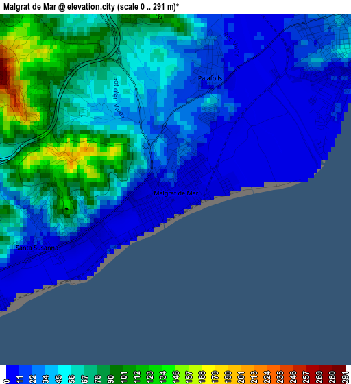
Below is the Elevation map of Malgrat de Mar, which displays elevation range with different colors. Scale of the first map is from 0 to 291 m (0 to 955 ft) with average elevation of 47.5 meters (=156 ft) [note 1]
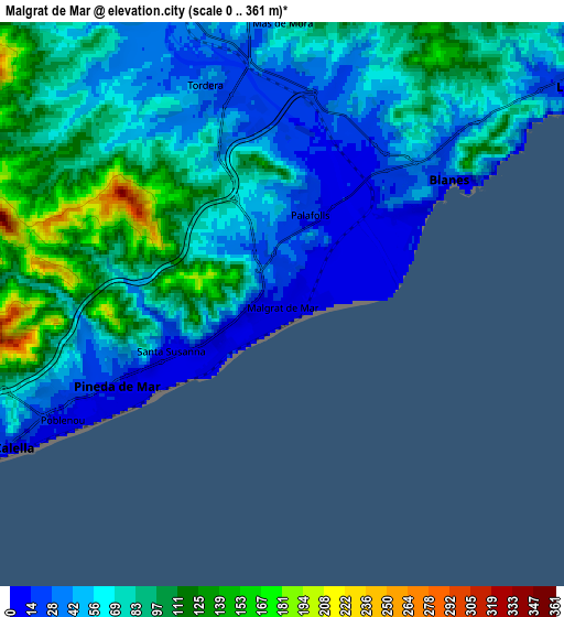
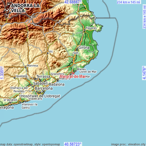
These maps also provides idea of topography and contour of this city, they are displayed at different zoom levels. More info about maps, scale and edge coordinates you can find below images.
| \ | Map #1 | Map #2 | Topo.Map |
| Scale [m] | 0..291 m | 0..361 m | × |
| Scale [ft] | 0..955 ft | 0..1184 ft | × |
| Average | 47.5 m = 156 ft | 70.4 m = 231 ft | × |
| Width | 7.3 km = 4.5 mi | 14.61 km = 9.1 mi | 233.7 km = 145.2 mi |
| Height | 7.3 km = 4.5 mi | 14.61 km = 9.1 mi | 233.7 km = 145.2 mi |
| ↑Max Latitude | 41.67945° | 41.712263° | 42.68887° |
| Latitude at center | 41.64662° | 41.64662° | 41.64662° |
| ↓Min Latitude | 41.613773° | 41.58091° | 40.58723° |
| ← Min Longitude | 2.697405° | 2.653459° | 1.3351° |
| Longitude center | 2.74135° | 2.74135° | 2.74135° |
| →Max Longitude | 2.785295° | 2.829241° | 4.1476° |
Nearby cities:
Cities around Malgrat de Mar sort by population:
• Blanes elevation 16 m
5.1 km,  53°
53°
• Lloret de Mar 14 m
10.5 km,  55°
55°
• Pineda de Mar 12 m
4.8 km,  244°
244°
• Calella 15 m
8.1 km, 243°
• Tordera 41 m
6.1 km,  342°
342°
• Canet de Mar 31 m
14.7 km, 244°
• Sant Pol de Mar 29 m
11.4 km, 244°
• Hostalric 67 m
14.6 km,  322°
322°
• Santa Susanna 4 m
2.5 km,  234°
234°
• Massanes 151 m
15.1 km,  331°
331°
• Sant Iscle de Vallalta 247 m
14.9 km,  257°
257°
• Palafolls 22 m
2.3 km,  17°
17°
Multilingual:
 En español:
Malgrat de Mar elevación 9 m.
 En France:
Malgrat de Mar élévation 9 m.
 Auf Deutsch:
Malgrat de Mar höhe über dem Meeresspiegel ist 9 m.

Sources and notes:
- [note 1] Map square and city borders are not equal. Map elevation data is calculated only from area inside that square.
- [src 1] Elevation data from geonames database provided with same terms of usage.
- [src 2] The elevation map of Malgrat de Mar is generated using elevation data from NASA's 3 arcsec (90m) resolution SRTM data.
- [src 3] Base (background) map © OpenStreetMap contributors tiles are generated by Geofabrik and OpenTopoMap.
Copyright & License:
This Malgrat de Mar Elevation Map is licensed under CC BY-SA. You may reuse any part from this page, if you give a proper credit by linking to this URL:
 More info on terms of use page.