Canet lo Roig elevation
Canet lo Roig (Valencia, Província de Castelló), Spain elevation is 333 meters and Canet lo Roig elevation in feet is 1093 ft above sea level [src 1]. Canet lo Roig is a seat of a third-order administrative division (feature code) with elevation that is 270 meters (886 ft) smaller than average city elevation in Spain.
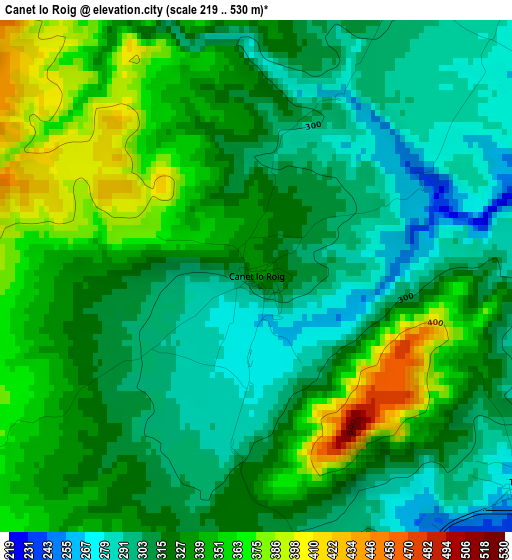
Below is the Elevation map of Canet lo Roig, which displays elevation range with different colors. Scale of the first map is from 219 to 530 m (719 to 1739 ft) with average elevation of 325.1 meters (=1067 ft) [note 1]
These maps also provides idea of topography and contour of this city, they are displayed at different zoom levels. More info about maps, scale and edge coordinates you can find below images.
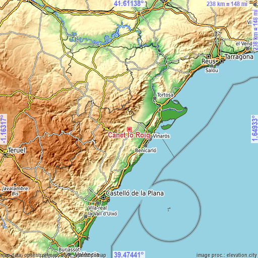
| \ | Map #1 | Topo.Map |
| Scale [m] | 219..530 m | × |
| Scale [ft] | 719..1739 ft | × |
| Average | 325.1 m = 1067 ft | × |
| Width | 7.43 km = 4.6 mi | 237.6 km = 147.6 mi |
| Height | 7.43 km = 4.6 mi | 237.6 km = 147.6 mi |
| ↑Max Latitude | 40.584802° | 41.61138° |
| Latitude at center | 40.55142° | 40.55142° |
| ↓Min Latitude | 40.518021° | 39.47441° |
| ← Min Longitude | 0.199135° | -1.16317° |
| Longitude center | 0.24308° | 0.24308° |
| →Max Longitude | 0.287025° | 1.64933° |
Nearby cities:
Cities around Canet lo Roig sort by population:
• Vinaròs elevation 12 m
21.6 km,  114°
114°
• Alcanar 67 m
20.1 km,  92°
92°
• Ulldecona 141 m
18 km,  73°
73°
• Càlig 120 m
13.7 km,  136°
136°
• Traiguera 280 m
4.9 km,  126°
126°
• Rosell 466 m
7.6 km,  346°
346°
• Chert/Xert 456 m
8 km,  243°
243°
• Catí 665 m
20.6 km, 244°
• Sant Jordi 173 m
8.8 km,  121°
121°
• Cervera del Maestre 273 m
11.2 km,  165°
165°
• Vallibona 668 m
17.6 km,  289°
289°
• Castell de Cabres 1139 m
20.9 km,  305°
305°
Multilingual:
 En español:
Canet lo Roig elevación 333 m.
 En France:
Canet lo Roig élévation 333 m.
 Auf Deutsch:
Canet lo Roig höhe über dem Meeresspiegel ist 333 m.

Sources and notes:
- [note 1] Map square and city borders are not equal. Map elevation data is calculated only from area inside that square.
- [src 1] Elevation data from geonames database provided with same terms of usage.
- [src 2] The elevation map of Canet lo Roig is generated using elevation data from NASA's 3 arcsec (90m) resolution SRTM data.
- [src 3] Base (background) map © OpenStreetMap contributors tiles are generated by Geofabrik and OpenTopoMap.
Copyright & License:
This Canet lo Roig Elevation Map is licensed under CC BY-SA. You may reuse any part from this page, if you give a proper credit by linking to this URL:
 More info on terms of use page.