Carcaboso elevation
Carcaboso (Extremadura, Provincia de Cáceres), Spain elevation is 277 meters and Carcaboso elevation in feet is 909 ft above sea level [src 1]. Carcaboso is a seat of a third-order administrative division (feature code) with elevation that is 326 meters (1070 ft) smaller than average city elevation in Spain.
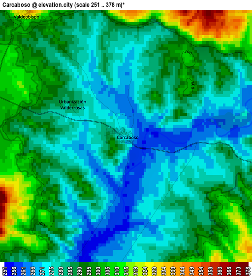
Below is the Elevation map of Carcaboso, which displays elevation range with different colors. Scale of the first map is from 251 to 378 m (823 to 1240 ft) with average elevation of 286.6 meters (=940 ft) [note 1]
These maps also provides idea of topography and contour of this city, they are displayed at different zoom levels. More info about maps, scale and edge coordinates you can find below images.
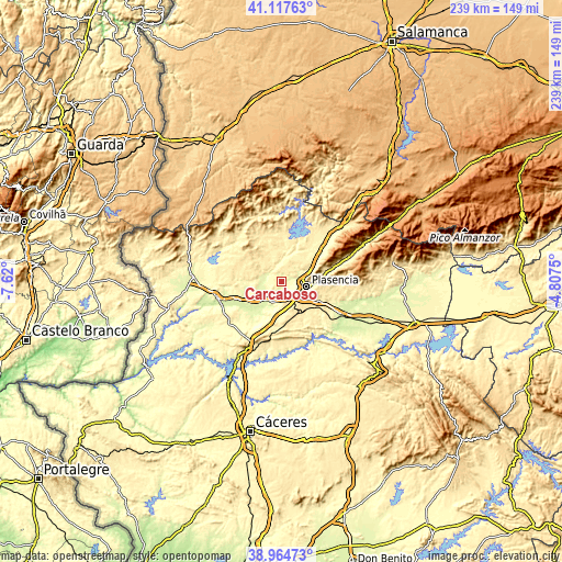
| \ | Map #1 | Topo.Map |
| Scale [m] | 251..378 m | × |
| Scale [ft] | 823..1240 ft | × |
| Average | 286.6 m = 940 ft | × |
| Width | 7.48 km = 4.6 mi | 239.4 km = 148.8 mi |
| Height | 7.48 km = 4.6 mi | 239.4 km = 148.8 mi |
| ↑Max Latitude | 40.083311° | 41.11763° |
| Latitude at center | 40.04968° | 40.04968° |
| ↓Min Latitude | 40.016032° | 38.96473° |
| ← Min Longitude | -6.257695° | -7.62° |
| Longitude center | -6.21375° | -6.21375° |
| →Max Longitude | -6.169805° | -4.8075° |
Nearby cities:
Cities around Carcaboso sort by population:
• Plasencia elevation 368 m
10.9 km,  100°
100°
• Montehermoso 399 m
12.3 km,  290°
290°
• Malpartida de Plasencia 457 m
16.3 km,  118°
118°
• Galisteo 305 m
9.4 km,  209°
209°
• Ahigal 390 m
15.7 km,  7°
7°
• Ríolobos 269 m
16.3 km, 208°
• Santibáñez el Bajo 374 m
14.1 km,  356°
356°
• Valdeobispo 339 m
4.7 km,  322°
322°
• Guijo de Granadilla 392 m
16.6 km, 14°
• Aceituna 485 m
15.1 km, 317°
• Morcillo 272 m
16 km,  257°
257°
• Oliva de Plasencia 410 m
12.9 km,  57°
57°
Multilingual:
 En español:
Carcaboso elevación 277 m.
 En France:
Carcaboso élévation 277 m.
 Auf Deutsch:
Carcaboso höhe über dem Meeresspiegel ist 277 m.

Sources and notes:
- [note 1] Map square and city borders are not equal. Map elevation data is calculated only from area inside that square.
- [src 1] Elevation data from geonames database provided with same terms of usage.
- [src 2] The elevation map of Carcaboso is generated using elevation data from NASA's 3 arcsec (90m) resolution SRTM data.
- [src 3] Base (background) map © OpenStreetMap contributors tiles are generated by Geofabrik and OpenTopoMap.
Copyright & License:
This Carcaboso Elevation Map is licensed under CC BY-SA. You may reuse any part from this page, if you give a proper credit by linking to this URL:
 More info on terms of use page.