Aceituna elevation
Aceituna (Extremadura, Provincia de Cáceres), Spain elevation is 485 meters and Aceituna elevation in feet is 1591 ft above sea level [src 1]. Aceituna is a seat of a third-order administrative division (feature code) with elevation that is 118 meters (387 ft) smaller than average city elevation in Spain.
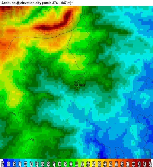
Below is the Elevation map of Aceituna, which displays elevation range with different colors. Scale of the first map is from 374 to 647 m (1227 to 2123 ft) with average elevation of 465.8 meters (=1528 ft) [note 1]
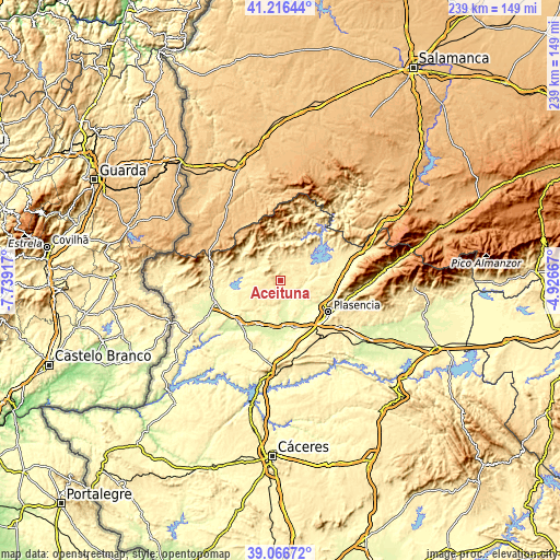
These maps also provides idea of topography and contour of this city, they are displayed at different zoom levels. More info about maps, scale and edge coordinates you can find below images.
| \ | Map #1 | Topo.Map |
| Scale [m] | 374..647 m | × |
| Scale [ft] | 1227..2123 ft | × |
| Average | 465.8 m = 1528 ft | × |
| Width | 7.47 km = 4.6 mi | 239 km = 148.5 mi |
| Height | 7.47 km = 4.6 mi | 239 km = 148.5 mi |
| ↑Max Latitude | 40.183662° | 41.21644° |
| Latitude at center | 40.15008° | 40.15008° |
| ↓Min Latitude | 40.116482° | 39.06672° |
| ← Min Longitude | -6.376865° | -7.73917° |
| Longitude center | -6.33292° | -6.33292° |
| →Max Longitude | -6.288975° | -4.92667° |
Nearby cities:
Cities around Aceituna sort by population:
• Montehermoso elevation 399 m
7.1 km,  191°
191°
• Guijo de Galisteo 427 m
9.1 km,  226°
226°
• Santibáñez el Bajo 374 m
9.7 km,  72°
72°
• Valdeobispo 339 m
10.4 km,  135°
135°
• Torrecilla de los Ángeles 453 m
13 km,  327°
327°
• Villa del Campo 476 m
8 km,  263°
263°
• Pozuelo de Zarzón 468 m
6.9 km,  268°
268°
• Villanueva de la Sierra 503 m
8.5 km,  312°
312°
• Palomero 453 m
11.8 km,  23°
23°
• Santa Cruz de Paniagua 475 m
4.7 km,  352°
352°
• Guijo de Coria 446 m
12.4 km,  243°
243°
• Cerezo 402 m
13.1 km,  42°
42°
Multilingual:
 En español:
Aceituna elevación 485 m.
 En France:
Aceituna élévation 485 m.
 Auf Deutsch:
Aceituna höhe über dem Meeresspiegel ist 485 m.

Sources and notes:
- [note 1] Map square and city borders are not equal. Map elevation data is calculated only from area inside that square.
- [src 1] Elevation data from geonames database provided with same terms of usage.
- [src 2] The elevation map of Aceituna is generated using elevation data from NASA's 3 arcsec (90m) resolution SRTM data.
- [src 3] Base (background) map © OpenStreetMap contributors tiles are generated by Geofabrik and OpenTopoMap.
Copyright & License:
This Aceituna Elevation Map is licensed under CC BY-SA. You may reuse any part from this page, if you give a proper credit by linking to this URL:
 More info on terms of use page.