Casas Bajas elevation
Casas Bajas (Valencia, Província de València), Spain elevation is 708 meters and Casas Bajas elevation in feet is 2323 ft above sea level [src 1]. Casas Bajas is a seat of a third-order administrative division (feature code) with elevation that is 105 meters (344 ft) bigger than average city elevation in Spain.
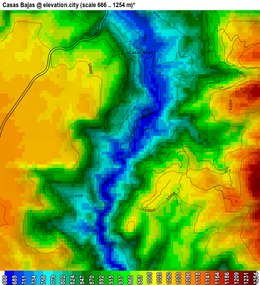
Below is the Elevation map of Casas Bajas, which displays elevation range with different colors. Scale of the first map is from 666 to 1254 m (2185 to 4114 ft) with average elevation of 938.7 meters (=3080 ft) [note 1]
These maps also provides idea of topography and contour of this city, they are displayed at different zoom levels. More info about maps, scale and edge coordinates you can find below images.
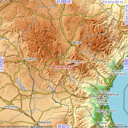
| \ | Map #1 | Topo.Map |
| Scale [m] | 666..1254 m | × |
| Scale [ft] | 2185..4114 ft | × |
| Average | 938.7 m = 3080 ft | × |
| Width | 7.48 km = 4.6 mi | 239.5 km = 148.8 mi |
| Height | 7.48 km = 4.6 mi | 239.5 km = 148.8 mi |
| ↑Max Latitude | 40.050318° | 41.08514° |
| Latitude at center | 40.01667° | 40.01667° |
| ↓Min Latitude | 39.983006° | 38.9312° |
| ← Min Longitude | -1.310615° | -2.67292° |
| Longitude center | -1.26667° | -1.26667° |
| →Max Longitude | -1.222725° | 0.13958° |
Nearby cities:
Cities around Casas Bajas sort by population:
• Landete elevation 977 m
15.5 km,  213°
213°
• Ademuz 756 m
5.3 km,  341°
341°
• Santa Cruz de Moya 901 m
7.4 km,  180°
180°
• Castielfabib 931 m
13.1 km,  345°
345°
• Moya 1082 m
11.3 km,  228°
228°
• Riodeva 953 m
14.9 km,  41°
41°
• Vallanca 1073 m
7.9 km,  314°
314°
• Casas Altas 807 m
1.9 km,  0°
0°
• Graja de Campalbo 1124 m
13 km, 180°
• Puebla de San Miguel 1211 m
11.9 km,  71°
71°
• Algarra 1188 m
14.3 km,  262°
262°
• Casas de Garcimolina 1159 m
12.9 km, 261°
Multilingual:
 En español:
Casas Bajas elevación 708 m.
 En France:
Casas Bajas élévation 708 m.
 Auf Deutsch:
Casas Bajas höhe über dem Meeresspiegel ist 708 m.

Sources and notes:
- [note 1] Map square and city borders are not equal. Map elevation data is calculated only from area inside that square.
- [src 1] Elevation data from geonames database provided with same terms of usage.
- [src 2] The elevation map of Casas Bajas is generated using elevation data from NASA's 3 arcsec (90m) resolution SRTM data.
- [src 3] Base (background) map © OpenStreetMap contributors tiles are generated by Geofabrik and OpenTopoMap.
Copyright & License:
This Casas Bajas Elevation Map is licensed under CC BY-SA. You may reuse any part from this page, if you give a proper credit by linking to this URL:
 More info on terms of use page.