Casas de Garcimolina elevation
Casas de Garcimolina (Castille-La Mancha, Provincia de Cuenca), Spain elevation is 1159 meters and Casas de Garcimolina elevation in feet is 3802 ft above sea level [src 1]. Casas de Garcimolina is a seat of a third-order administrative division (feature code) with elevation that is 556 meters (1824 ft) bigger than average city elevation in Spain.
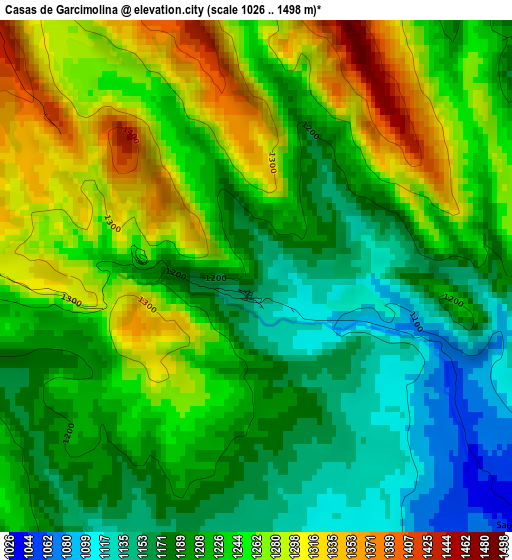
Below is the Elevation map of Casas de Garcimolina, which displays elevation range with different colors. Scale of the first map is from 1026 to 1498 m (3366 to 4915 ft) with average elevation of 1225.2 meters (=4020 ft) [note 1]
These maps also provides idea of topography and contour of this city, they are displayed at different zoom levels. More info about maps, scale and edge coordinates you can find below images.
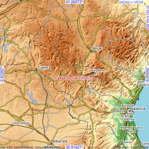
| \ | Map #1 | Topo.Map |
| Scale [m] | 1026..1498 m | × |
| Scale [ft] | 3366..4915 ft | × |
| Average | 1225.2 m = 4020 ft | × |
| Width | 7.49 km = 4.7 mi | 239.6 km = 148.9 mi |
| Height | 7.49 km = 4.7 mi | 239.5 km = 148.8 mi |
| ↑Max Latitude | 40.033656° | 41.06873° |
| Latitude at center | 40° | 40° |
| ↓Min Latitude | 39.966328° | 38.91427° |
| ← Min Longitude | -1.460615° | -2.82292° |
| Longitude center | -1.41667° | -1.41667° |
| →Max Longitude | -1.372725° | -0.01042° |
Nearby cities:
Cities around Casas de Garcimolina sort by population:
• Landete elevation 977 m
11.9 km,  159°
159°
• Ademuz 756 m
13 km,  58°
58°
• Santa Cruz de Moya 901 m
13.9 km,  113°
113°
• Salvacañete 1179 m
13.2 km,  327°
327°
• Casas Bajas 708 m
12.9 km,  81°
81°
• Moya 1082 m
7 km,  142°
142°
• Vallanca 1073 m
10.3 km,  43°
43°
• Fuentelespino de Moya 1114 m
10.2 km,  204°
204°
• Casas Altas 807 m
13.3 km,  73°
73°
• Alcalá de la Vega 1103 m
9.3 km,  293°
293°
• Campillos-Paravientos 1091 m
11.5 km,  260°
260°
• Algarra 1188 m
1.4 km,  270°
270°
Multilingual:
 En español:
Casas de Garcimolina elevación 1159 m.
 En France:
Casas de Garcimolina élévation 1159 m.
 Auf Deutsch:
Casas de Garcimolina höhe über dem Meeresspiegel ist 1159 m.
 На русском:
Casas de Garcimolina высота над уровнем моря 1159 м
Sources and notes:
- [note 1] Map square and city borders are not equal. Map elevation data is calculated only from area inside that square.
- [src 1] Elevation data from geonames database provided with same terms of usage.
- [src 2] The elevation map of Casas de Garcimolina is generated using elevation data from NASA's 3 arcsec (90m) resolution SRTM data.
- [src 3] Base (background) map © OpenStreetMap contributors tiles are generated by Geofabrik and OpenTopoMap.
Copyright & License:
This Casas de Garcimolina Elevation Map is licensed under CC BY-SA. You may reuse any part from this page, if you give a proper credit by linking to this URL:
 More info on terms of use page.