Casla elevation
Casla (Castille and León, Provincia de Segovia), Spain elevation is 1084 meters and Casla elevation in feet is 3556 ft above sea level [src 1]. Casla is a seat of a third-order administrative division (feature code) with elevation that is 481 meters (1578 ft) bigger than average city elevation in Spain.
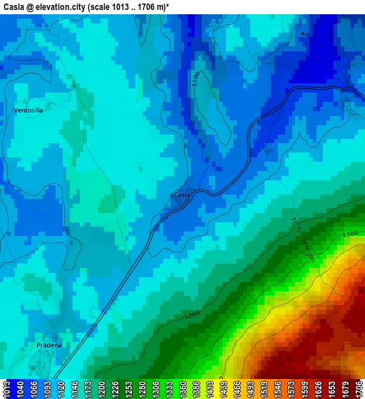
Below is the Elevation map of Casla, which displays elevation range with different colors. Scale of the first map is from 1013 to 1706 m (3323 to 5597 ft) with average elevation of 1170.9 meters (=3842 ft) [note 1]
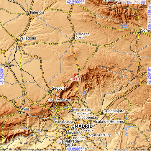
These maps also provides idea of topography and contour of this city, they are displayed at different zoom levels. More info about maps, scale and edge coordinates you can find below images.
| \ | Map #1 | Topo.Map |
| Scale [m] | 1013..1706 m | × |
| Scale [ft] | 3323..5597 ft | × |
| Average | 1170.9 m = 3842 ft | × |
| Width | 7.36 km = 4.6 mi | 235.4 km = 146.3 mi |
| Height | 7.36 km = 4.6 mi | 235.4 km = 146.3 mi |
| ↑Max Latitude | 41.199094° | 42.21609° |
| Latitude at center | 41.16602° | 41.16602° |
| ↓Min Latitude | 41.132929° | 40.09885° |
| ← Min Longitude | -3.700375° | -5.06268° |
| Longitude center | -3.65643° | -3.65643° |
| →Max Longitude | -3.612485° | -2.25018° |
Nearby cities:
Cities around Casla sort by population:
• Prádena elevation 1123 m
4 km,  221°
221°
• Arcones 1152 m
7.8 km,  226°
226°
• Matabuena 1152 m
11.6 km, 227°
• Cerezo de Abajo 1036 m
8 km,  43°
43°
• Cerezo de Arriba 1130 m
11.5 km,  45°
45°
• Duruelo 1011 m
7.8 km,  4°
4°
• Valleruela de Sepúlveda 1096 m
10 km,  284°
284°
• Santa Marta del Cerro 1028 m
6.3 km,  337°
337°
• Castroserna de Abajo 985 m
8 km,  305°
305°
• Sotillo 986 m
10.4 km,  8°
8°
• Robregordo 1300 m
8.4 km,  141°
141°
• Somosierra 1434 m
7.2 km,  120°
120°
Multilingual:
 En español:
Casla elevación 1084 m.
 En France:
Casla élévation 1084 m.


Sources and notes:
- [note 1] Map square and city borders are not equal. Map elevation data is calculated only from area inside that square.
- [src 1] Elevation data from geonames database provided with same terms of usage.
- [src 2] The elevation map of Casla is generated using elevation data from NASA's 3 arcsec (90m) resolution SRTM data.
- [src 3] Base (background) map © OpenStreetMap contributors tiles are generated by Geofabrik and OpenTopoMap.
Copyright & License:
This Casla Elevation Map is licensed under CC BY-SA. You may reuse any part from this page, if you give a proper credit by linking to this URL:
 More info on terms of use page.