Matabuena elevation
Matabuena (Castille and León, Provincia de Segovia), Spain elevation is 1152 meters and Matabuena elevation in feet is 3780 ft above sea level [src 1]. Matabuena is a seat of a third-order administrative division (feature code) with elevation that is 549 meters (1801 ft) bigger than average city elevation in Spain.
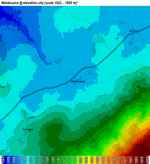
Below is the Elevation map of Matabuena, which displays elevation range with different colors. Scale of the first map is from 1022 to 1955 m (3353 to 6414 ft) with average elevation of 1231.1 meters (=4039 ft) [note 1]
These maps also provides idea of topography and contour of this city, they are displayed at different zoom levels. More info about maps, scale and edge coordinates you can find below images.
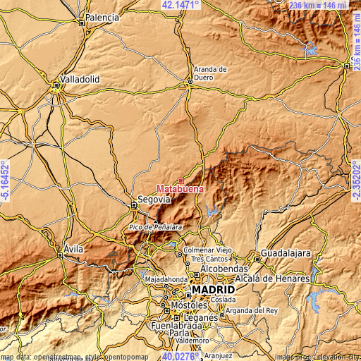
| \ | Map #1 | Topo.Map |
| Scale [m] | 1022..1955 m | × |
| Scale [ft] | 3353..6414 ft | × |
| Average | 1231.1 m = 4039 ft | × |
| Width | 7.36 km = 4.6 mi | 235.7 km = 146.5 mi |
| Height | 7.36 km = 4.6 mi | 235.7 km = 146.5 mi |
| ↑Max Latitude | 41.129009° | 42.1471° |
| Latitude at center | 41.0959° | 41.0959° |
| ↓Min Latitude | 41.062774° | 40.0276° |
| ← Min Longitude | -3.802215° | -5.16452° |
| Longitude center | -3.75827° | -3.75827° |
| →Max Longitude | -3.714325° | -2.35202° |
Nearby cities:
Cities around Matabuena sort by population:
• Prádena elevation 1123 m
7.6 km,  50°
50°
• Pedraza 1073 m
5.9 km,  311°
311°
• Navafría 1201 m
7.2 km,  230°
230°
• Arcones 1152 m
3.8 km, 49°
• Torre Val de San Pedro 1114 m
9.7 km,  256°
256°
• Braojos 1189 m
11.4 km,  122°
122°
• Casla 1084 m
11.6 km, 47°
• Gallegos 1237 m
3.3 km, 225°
• Valleruela de Sepúlveda 1096 m
10.3 km,  353°
353°
• Valleruela de Pedraza 1083 m
10.1 km,  336°
336°
• Arahuetes 1096 m
9.5 km,  299°
299°
• Castroserna de Abajo 985 m
12.7 km,  9°
9°
Multilingual:
 En español:
Matabuena elevación 1152 m.
 En France:
Matabuena élévation 1152 m.
 Auf Deutsch:
Matabuena höhe über dem Meeresspiegel ist 1152 m.

Sources and notes:
- [note 1] Map square and city borders are not equal. Map elevation data is calculated only from area inside that square.
- [src 1] Elevation data from geonames database provided with same terms of usage.
- [src 2] The elevation map of Matabuena is generated using elevation data from NASA's 3 arcsec (90m) resolution SRTM data.
- [src 3] Base (background) map © OpenStreetMap contributors tiles are generated by Geofabrik and OpenTopoMap.
Copyright & License:
This Matabuena Elevation Map is licensed under CC BY-SA. You may reuse any part from this page, if you give a proper credit by linking to this URL:
 More info on terms of use page.