Caspueñas elevation
Caspueñas (Castille-La Mancha, Provincia de Guadalajara), Spain elevation is 874 meters and Caspueñas elevation in feet is 2867 ft above sea level [src 1]. Caspueñas is a seat of a third-order administrative division (feature code) with elevation that is 271 meters (889 ft) bigger than average city elevation in Spain.
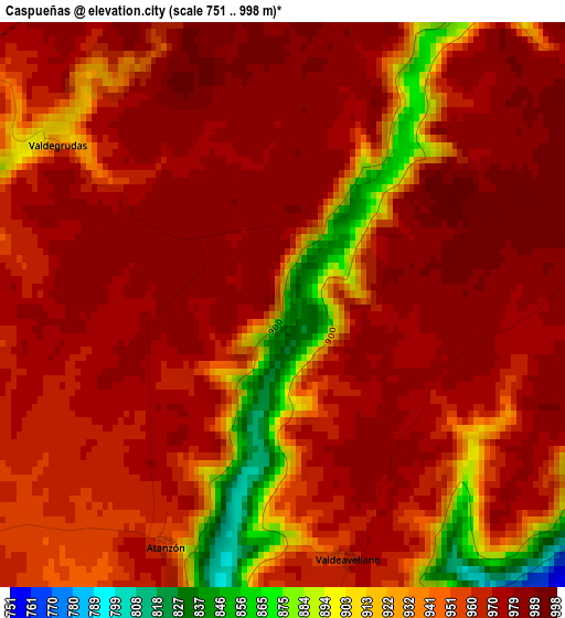
Below is the Elevation map of Caspueñas, which displays elevation range with different colors. Scale of the first map is from 751 to 998 m (2464 to 3274 ft) with average elevation of 956.5 meters (=3138 ft) [note 1]
These maps also provides idea of topography and contour of this city, they are displayed at different zoom levels. More info about maps, scale and edge coordinates you can find below images.
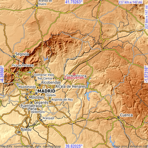
| \ | Map #1 | Topo.Map |
| Scale [m] | 751..998 m | × |
| Scale [ft] | 2464..3274 ft | × |
| Average | 956.5 m = 3138 ft | × |
| Width | 7.41 km = 4.6 mi | 237.1 km = 147.3 mi |
| Height | 7.41 km = 4.6 mi | 237.1 km = 147.3 mi |
| ↑Max Latitude | 40.728281° | 41.75263° |
| Latitude at center | 40.69497° | 40.69497° |
| ↓Min Latitude | 40.661643° | 39.62025° |
| ← Min Longitude | -3.023355° | -4.38566° |
| Longitude center | -2.97941° | -2.97941° |
| →Max Longitude | -2.935465° | -1.57316° |
Nearby cities:
Cities around Caspueñas sort by population:
• Brihuega elevation 918 m
11.8 km,  51°
51°
• Trijueque 999 m
8.9 km,  352°
352°
• Torija 971 m
6.7 km,  322°
322°
• Lupiana 760 m
11.4 km,  212°
212°
• Aldeanueva de Guadalajara 892 m
5.7 km,  252°
252°
• Cañizar 802 m
10.8 km, 318°
• Valdeavellano 969 m
3.4 km,  166°
166°
• Ciruelas 871 m
10.9 km,  304°
304°
• Centenera 933 m
7.8 km,  230°
230°
• Valfermoso de Tajuña 956 m
8.7 km, 165°
• Valdegrudas 977 m
3.3 km, 303°
• Atanzón 945 m
3.4 km, 205°
Multilingual:
 En español:
Caspueñas elevación 874 m.
 En France:
Caspueñas élévation 874 m.
 Auf Deutsch:
Caspueñas höhe über dem Meeresspiegel ist 874 m.

Sources and notes:
- [note 1] Map square and city borders are not equal. Map elevation data is calculated only from area inside that square.
- [src 1] Elevation data from geonames database provided with same terms of usage.
- [src 2] The elevation map of Caspueñas is generated using elevation data from NASA's 3 arcsec (90m) resolution SRTM data.
- [src 3] Base (background) map © OpenStreetMap contributors tiles are generated by Geofabrik and OpenTopoMap.
Copyright & License:
This Caspueñas Elevation Map is licensed under CC BY-SA. You may reuse any part from this page, if you give a proper credit by linking to this URL:
 More info on terms of use page.