Cañizar elevation
Cañizar (Castille-La Mancha, Provincia de Guadalajara), Spain elevation is 802 meters and Cañizar elevation in feet is 2631 ft above sea level [src 1]. Cañizar is a seat of a third-order administrative division (feature code) with elevation that is 199 meters (653 ft) bigger than average city elevation in Spain.
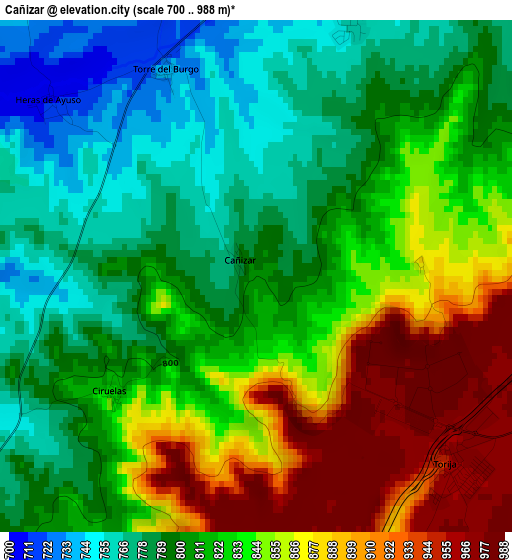
Below is the Elevation map of Cañizar, which displays elevation range with different colors. Scale of the first map is from 700 to 988 m (2297 to 3241 ft) with average elevation of 826.8 meters (=2713 ft) [note 1]
These maps also provides idea of topography and contour of this city, they are displayed at different zoom levels. More info about maps, scale and edge coordinates you can find below images.
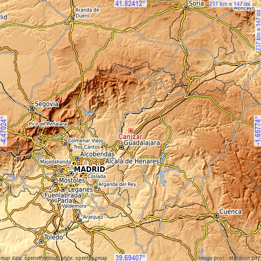
| \ | Map #1 | Topo.Map |
| Scale [m] | 700..988 m | × |
| Scale [ft] | 2297..3241 ft | × |
| Average | 826.8 m = 2713 ft | × |
| Width | 7.4 km = 4.6 mi | 236.8 km = 147.1 mi |
| Height | 7.4 km = 4.6 mi | 236.8 km = 147.1 mi |
| ↑Max Latitude | 40.800904° | 41.82412° |
| Latitude at center | 40.76763° | 40.76763° |
| ↓Min Latitude | 40.734339° | 39.69407° |
| ← Min Longitude | -3.107935° | -4.47024° |
| Longitude center | -3.06399° | -3.06399° |
| →Max Longitude | -3.020045° | -1.65774° |
Nearby cities:
Cities around Cañizar sort by population:
• Yunquera de Henares elevation 688 m
8.5 km,  257°
257°
• Trijueque 999 m
6.1 km,  83°
83°
• Torija 971 m
4.1 km,  132°
132°
• Tórtola de Henares 730 m
8.6 km,  215°
215°
• Hita 815 m
6.2 km,  14°
14°
• Torre del Burgo 745 m
2.9 km,  337°
337°
• Alarilla 800 m
9.4 km, 339°
• Aldeanueva de Guadalajara 892 m
9.9 km,  170°
170°
• Ciruelas 871 m
2.7 km, 223°
• Valdearenas 790 m
7.6 km,  52°
52°
• Valdegrudas 977 m
7.6 km,  145°
145°
• Taragudo 745 m
6 km,  349°
349°
Multilingual:
 En español:
Cañizar elevación 802 m.
 En France:
Cañizar élévation 802 m.


Sources and notes:
- [note 1] Map square and city borders are not equal. Map elevation data is calculated only from area inside that square.
- [src 1] Elevation data from geonames database provided with same terms of usage.
- [src 2] The elevation map of Cañizar is generated using elevation data from NASA's 3 arcsec (90m) resolution SRTM data.
- [src 3] Base (background) map © OpenStreetMap contributors tiles are generated by Geofabrik and OpenTopoMap.
Copyright & License:
This Cañizar Elevation Map is licensed under CC BY-SA. You may reuse any part from this page, if you give a proper credit by linking to this URL:
 More info on terms of use page.