Castillejo-Sierra elevation
Castillejo-Sierra (Castille-La Mancha, Provincia de Cuenca), Spain elevation is 1000 meters and Castillejo-Sierra elevation in feet is 3281 ft above sea level [src 1]. Castillejo-Sierra is a seat of a third-order administrative division (feature code) with elevation that is 397 meters (1302 ft) bigger than average city elevation in Spain.
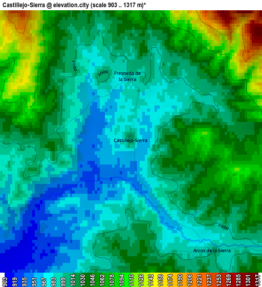
Below is the Elevation map of Castillejo-Sierra, which displays elevation range with different colors. Scale of the first map is from 903 to 1317 m (2963 to 4321 ft) with average elevation of 1019 meters (=3343 ft) [note 1]
These maps also provides idea of topography and contour of this city, they are displayed at different zoom levels. More info about maps, scale and edge coordinates you can find below images.
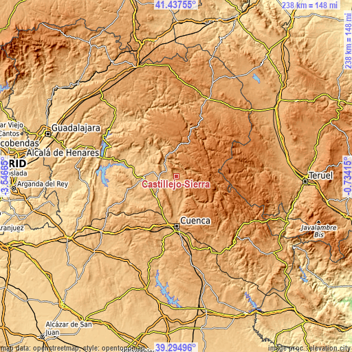
| \ | Map #1 | Topo.Map |
| Scale [m] | 903..1317 m | × |
| Scale [ft] | 2963..4321 ft | × |
| Average | 1019 m = 3343 ft | × |
| Width | 7.44 km = 4.6 mi | 238.2 km = 148 mi |
| Height | 7.44 km = 4.6 mi | 238.2 km = 148 mi |
| ↑Max Latitude | 40.40824° | 41.43755° |
| Latitude at center | 40.37477° | 40.37477° |
| ↓Min Latitude | 40.341283° | 39.29496° |
| ← Min Longitude | -2.184345° | -3.54665° |
| Longitude center | -2.1404° | -2.1404° |
| →Max Longitude | -2.096455° | -0.73415° |
Nearby cities:
Cities around Castillejo-Sierra sort by population:
• Villalba de la Sierra elevation 987 m
16.2 km,  164°
164°
• Cañamares 888 m
12 km,  315°
315°
• Cañizares 1061 m
16.6 km,  344°
344°
• Villaconejos de Trabaque 814 m
15.4 km,  280°
280°
• Albalate de las Nogueras 844 m
11.6 km,  265°
265°
• Zarzuela 1136 m
13.1 km,  168°
168°
• La Frontera 977 m
7.1 km,  294°
294°
• Torralba 910 m
14.7 km,  236°
236°
• Fuertescusa 987 m
11.6 km, 344°
• Arcos de la Sierra 1011 m
3.9 km,  143°
143°
• Portilla 1070 m
10.7 km,  152°
152°
• Fresneda de la Sierra 991 m
1.8 km,  354°
354°
Multilingual:
 En español:
Castillejo-Sierra elevación 1000 m.
 En France:
Castillejo-Sierra élévation 1000 m.
 Auf Deutsch:
Castillejo-Sierra höhe über dem Meeresspiegel ist 1000 m.
 На русском:
Castillejo-Sierra высота над уровнем моря 1000 м
Sources and notes:
- [note 1] Map square and city borders are not equal. Map elevation data is calculated only from area inside that square.
- [src 1] Elevation data from geonames database provided with same terms of usage.
- [src 2] The elevation map of Castillejo-Sierra is generated using elevation data from NASA's 3 arcsec (90m) resolution SRTM data.
- [src 3] Base (background) map © OpenStreetMap contributors tiles are generated by Geofabrik and OpenTopoMap.
Copyright & License:
This Castillejo-Sierra Elevation Map is licensed under CC BY-SA. You may reuse any part from this page, if you give a proper credit by linking to this URL:
 More info on terms of use page.