Codorniz elevation
Codorniz (Castille and León, Provincia de Segovia), Spain elevation is 890 meters and Codorniz elevation in feet is 2920 ft above sea level [src 1]. Codorniz is a seat of a third-order administrative division (feature code) with elevation that is 287 meters (942 ft) bigger than average city elevation in Spain.
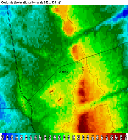
Below is the Elevation map of Codorniz, which displays elevation range with different colors. Scale of the first map is from 852 to 933 m (2795 to 3061 ft) with average elevation of 886.3 meters (=2908 ft) [note 1]
These maps also provides idea of topography and contour of this city, they are displayed at different zoom levels. More info about maps, scale and edge coordinates you can find below images.
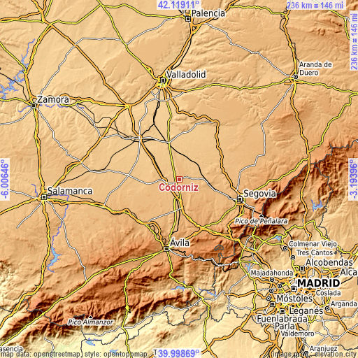
| \ | Map #1 | Topo.Map |
| Scale [m] | 852..933 m | × |
| Scale [ft] | 2795..3061 ft | × |
| Average | 886.3 m = 2908 ft | × |
| Width | 7.37 km = 4.6 mi | 235.8 km = 146.5 mi |
| Height | 7.37 km = 4.6 mi | 235.8 km = 146.5 mi |
| ↑Max Latitude | 41.100574° | 42.11911° |
| Latitude at center | 41.06745° | 41.06745° |
| ↓Min Latitude | 41.03431° | 39.99869° |
| ← Min Longitude | -4.644155° | -6.00646° |
| Longitude center | -4.60021° | -4.60021° |
| →Max Longitude | -4.556265° | -3.19396° |
Nearby cities:
Cities around Codorniz sort by population:
• Martín Muñoz de las Posadas elevation 897 m
8 km,  177°
177°
• Juarros de Voltoya 853 m
7.9 km,  120°
120°
• Montejo de Arévalo 803 m
9.7 km,  326°
326°
• Rapariegos 858 m
5.4 km,  304°
304°
• Aldeanueva del Codonal 859 m
5 km,  70°
70°
• Martín Muñoz de la Dehesa 835 m
7.3 km,  269°
269°
• San Cristóbal de la Vega 859 m
6.2 km,  323°
323°
• Gutierre-Muñoz 886 m
9.9 km,  198°
198°
• Orbita 867 m
8.7 km,  207°
207°
• Donhierro 805 m
9.7 km, 303°
• Tolocirio 809 m
8.6 km, 330°
• Aldehuela del Codonal 861 m
5.3 km,  104°
104°
Multilingual:
 En español:
Codorniz elevación 890 m.
 En France:
Codorniz élévation 890 m.
 Auf Deutsch:
Codorniz höhe über dem Meeresspiegel ist 890 m.

Sources and notes:
- [note 1] Map square and city borders are not equal. Map elevation data is calculated only from area inside that square.
- [src 1] Elevation data from geonames database provided with same terms of usage.
- [src 2] The elevation map of Codorniz is generated using elevation data from NASA's 3 arcsec (90m) resolution SRTM data.
- [src 3] Base (background) map © OpenStreetMap contributors tiles are generated by Geofabrik and OpenTopoMap.
Copyright & License:
This Codorniz Elevation Map is licensed under CC BY-SA. You may reuse any part from this page, if you give a proper credit by linking to this URL:
 More info on terms of use page.