Colldejou elevation
Colldejou (Catalonia, Província de Tarragona), Spain elevation is 448 meters and Colldejou elevation in feet is 1470 ft above sea level [src 1]. Colldejou is a seat of a third-order administrative division (feature code) with elevation that is 155 meters (509 ft) smaller than average city elevation in Spain.
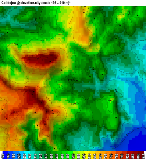
Below is the Elevation map of Colldejou, which displays elevation range with different colors. Scale of the first map is from 136 to 919 m (446 to 3015 ft) with average elevation of 480.3 meters (=1576 ft) [note 1]
These maps also provides idea of topography and contour of this city, they are displayed at different zoom levels. More info about maps, scale and edge coordinates you can find below images.
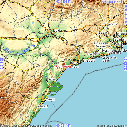
| \ | Map #1 | Topo.Map |
| Scale [m] | 136..919 m | × |
| Scale [ft] | 446..3015 ft | × |
| Average | 480.3 m = 1576 ft | × |
| Width | 7.36 km = 4.6 mi | 235.7 km = 146.5 mi |
| Height | 7.36 km = 4.6 mi | 235.6 km = 146.4 mi |
| ↑Max Latitude | 41.132807° | 42.15084° |
| Latitude at center | 41.0997° | 41.0997° |
| ↓Min Latitude | 41.066576° | 40.03146° |
| ← Min Longitude | 0.843225° | -0.51908° |
| Longitude center | 0.88717° | 0.88717° |
| →Max Longitude | 0.931115° | 2.29342° |
Nearby cities:
Cities around Colldejou sort by population:
• Cambrils elevation 13 m
14.8 km,  102°
102°
• Mont-roig del Camp 112 m
6.2 km, 103°
• Riudoms 117 m
14.1 km,  74°
74°
• Falset 372 m
7.6 km,  312°
312°
• les Borges del Camp 217 m
13.2 km,  55°
55°
• Alforja 373 m
14.4 km,  30°
30°
• Riudecols 318 m
10.7 km,  44°
44°
• Botarell 198 m
9.5 km, 64°
• el Masroig 139 m
13.4 km,  286°
286°
• Riudecanyes 204 m
7.6 km, 60°
• Duesaigües 335 m
6.8 km, 34°
• Vilanova d'Escornalbou 280 m
4.3 km, 63°
Multilingual:
 En español:
Colldejou elevación 448 m.
 En France:
Colldejou élévation 448 m.
 Auf Deutsch:
Colldejou höhe über dem Meeresspiegel ist 448 m.

Sources and notes:
- [note 1] Map square and city borders are not equal. Map elevation data is calculated only from area inside that square.
- [src 1] Elevation data from geonames database provided with same terms of usage.
- [src 2] The elevation map of Colldejou is generated using elevation data from NASA's 3 arcsec (90m) resolution SRTM data.
- [src 3] Base (background) map © OpenStreetMap contributors tiles are generated by Geofabrik and OpenTopoMap.
Copyright & License:
This Colldejou Elevation Map is licensed under CC BY-SA. You may reuse any part from this page, if you give a proper credit by linking to this URL:
 More info on terms of use page.