Cristóbal elevation
Cristóbal (Castille and León, Provincia de Salamanca), Spain elevation is 872 meters and Cristóbal elevation in feet is 2861 ft above sea level [src 1]. Cristóbal is a seat of a third-order administrative division (feature code) with elevation that is 269 meters (883 ft) bigger than average city elevation in Spain.
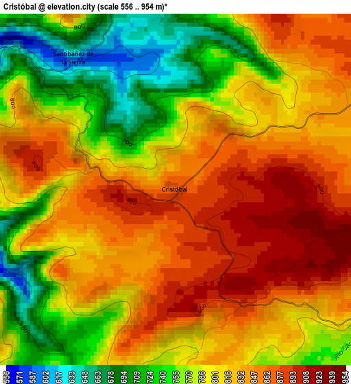
Below is the Elevation map of Cristóbal, which displays elevation range with different colors. Scale of the first map is from 556 to 954 m (1824 to 3130 ft) with average elevation of 806.1 meters (=2645 ft) [note 1]
These maps also provides idea of topography and contour of this city, they are displayed at different zoom levels. More info about maps, scale and edge coordinates you can find below images.
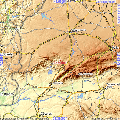
| \ | Map #1 | Topo.Map |
| Scale [m] | 556..954 m | × |
| Scale [ft] | 1824..3130 ft | × |
| Average | 806.1 m = 2645 ft | × |
| Width | 7.43 km = 4.6 mi | 237.9 km = 147.8 mi |
| Height | 7.43 km = 4.6 mi | 237.9 km = 147.8 mi |
| ↑Max Latitude | 40.502653° | 41.5305° |
| Latitude at center | 40.46923° | 40.46923° |
| ↓Min Latitude | 40.43579° | 39.39092° |
| ← Min Longitude | -5.933615° | -7.29592° |
| Longitude center | -5.88967° | -5.88967° |
| →Max Longitude | -5.845725° | -4.48342° |
Nearby cities:
Cities around Cristóbal sort by population:
• Miranda del Castañar elevation 649 m
9.1 km,  280°
280°
• Valero 582 m
8.6 km,  328°
328°
• San Esteban de la Sierra 631 m
4.4 km,  341°
341°
• San Miguel de Valero 937 m
8.7 km, 341°
• Valdefuentes de Sangusín 893 m
4.8 km,  94°
94°
• Santibáñez de la Sierra 622 m
3.6 km,  322°
322°
• Colmenar de Montemayor 838 m
9.6 km,  216°
216°
• Horcajo de Montemayor 737 m
5.2 km,  184°
184°
• Pinedas 791 m
6.6 km,  245°
245°
• Valdehijaderos 779 m
6.6 km,  147°
147°
• Molinillo 724 m
4.7 km,  269°
269°
• Valverde de Valdelacasa 805 m
9.3 km,  81°
81°
Multilingual:
 En español:
Cristóbal elevación 872 m.
 En France:
Cristóbal élévation 872 m.
 Auf Deutsch:
Cristóbal höhe über dem Meeresspiegel ist 872 m.

Sources and notes:
- [note 1] Map square and city borders are not equal. Map elevation data is calculated only from area inside that square.
- [src 1] Elevation data from geonames database provided with same terms of usage.
- [src 2] The elevation map of Cristóbal is generated using elevation data from NASA's 3 arcsec (90m) resolution SRTM data.
- [src 3] Base (background) map © OpenStreetMap contributors tiles are generated by Geofabrik and OpenTopoMap.
Copyright & License:
This Cristóbal Elevation Map is licensed under CC BY-SA. You may reuse any part from this page, if you give a proper credit by linking to this URL:
 More info on terms of use page.