Valero elevation
Valero (Castille and León, Provincia de Salamanca), Spain elevation is 582 meters and Valero elevation in feet is 1909 ft above sea level [src 1]. Valero is a seat of a third-order administrative division (feature code) with elevation that is 21 meters (69 ft) smaller than average city elevation in Spain.
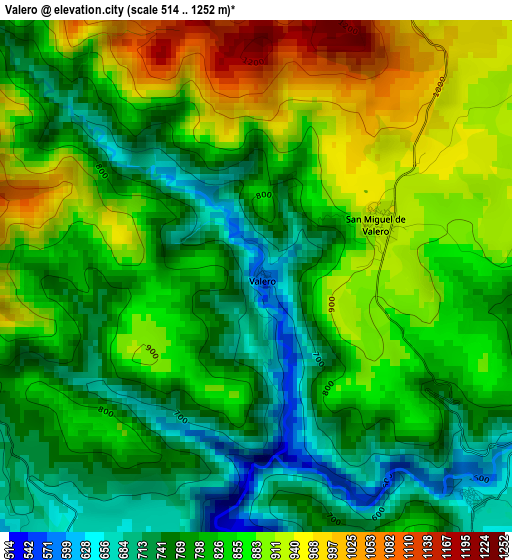
Below is the Elevation map of Valero, which displays elevation range with different colors. Scale of the first map is from 514 to 1252 m (1686 to 4108 ft) with average elevation of 827.3 meters (=2714 ft) [note 1]
These maps also provides idea of topography and contour of this city, they are displayed at different zoom levels. More info about maps, scale and edge coordinates you can find below images.
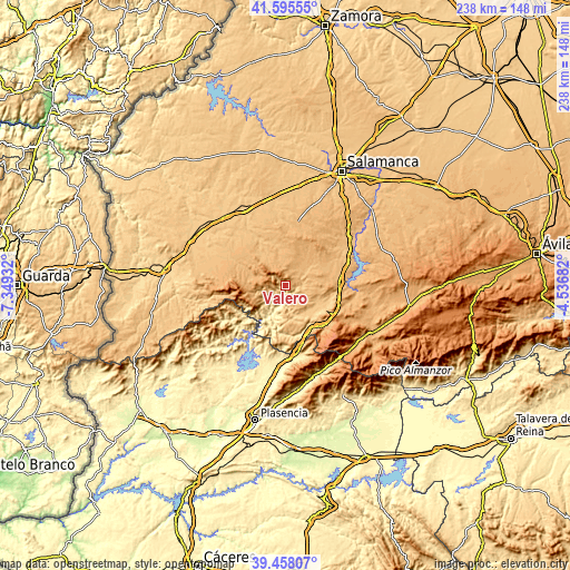
| \ | Map #1 | Topo.Map |
| Scale [m] | 514..1252 m | × |
| Scale [ft] | 1686..4108 ft | × |
| Average | 827.3 m = 2714 ft | × |
| Width | 7.43 km = 4.6 mi | 237.7 km = 147.7 mi |
| Height | 7.43 km = 4.6 mi | 237.7 km = 147.7 mi |
| ↑Max Latitude | 40.56872° | 41.59555° |
| Latitude at center | 40.53533° | 40.53533° |
| ↓Min Latitude | 40.501923° | 39.45807° |
| ← Min Longitude | -5.987015° | -7.34932° |
| Longitude center | -5.94307° | -5.94307° |
| →Max Longitude | -5.899125° | -4.53682° |
Nearby cities:
Cities around Valero sort by population:
• Linares de Riofrío elevation 958 m
5.7 km,  19°
19°
• Miranda del Castañar 649 m
7.2 km,  218°
218°
• San Esteban de la Sierra 631 m
4.4 km,  135°
135°
• San Miguel de Valero 937 m
1.9 km,  61°
61°
• Escurial de la Sierra 960 m
9.2 km,  353°
353°
• Navarredonda de la Rinconada 1026 m
9.8 km,  323°
323°
• Santibáñez de la Sierra 622 m
5.1 km,  152°
152°
• Sequeros 939 m
7.4 km,  250°
250°
• Garcibuey 700 m
4.9 km,  243°
243°
• Villanueva del Conde 800 m
6.5 km, 244°
• Cristóbal 872 m
8.6 km, 148°
• Molinillo 724 m
7.4 km,  181°
181°
Multilingual:
 En español:
Valero elevación 582 m.
 En France:
Valero élévation 582 m.


Sources and notes:
- [note 1] Map square and city borders are not equal. Map elevation data is calculated only from area inside that square.
- [src 1] Elevation data from geonames database provided with same terms of usage.
- [src 2] The elevation map of Valero is generated using elevation data from NASA's 3 arcsec (90m) resolution SRTM data.
- [src 3] Base (background) map © OpenStreetMap contributors tiles are generated by Geofabrik and OpenTopoMap.
Copyright & License:
This Valero Elevation Map is licensed under CC BY-SA. You may reuse any part from this page, if you give a proper credit by linking to this URL:
 More info on terms of use page.