Eibar elevation
Eibar (Basque Country, Gipuzkoa), Spain elevation is 133 meters and Eibar elevation in feet is 436 ft above sea level [src 1]. Eibar is a seat of a third-order administrative division (feature code) with elevation that is 470 meters (1542 ft) smaller than average city elevation in Spain.
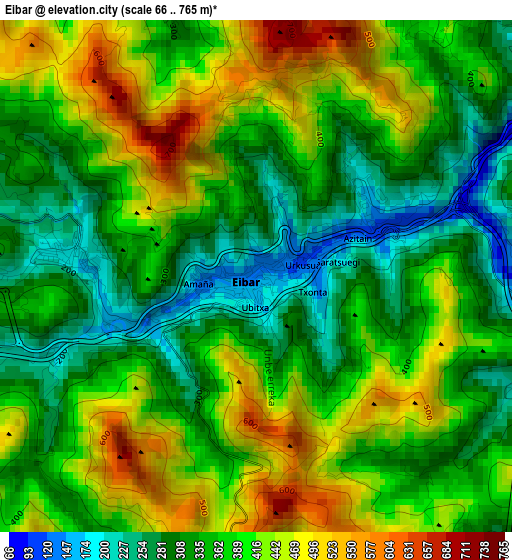
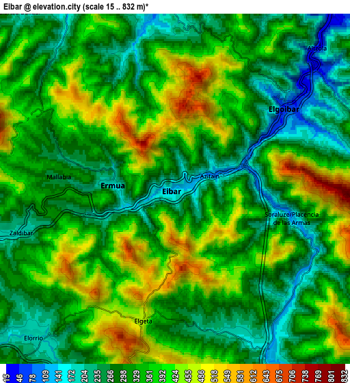
Below is the Elevation map of Eibar, which displays elevation range with different colors. Scale of the first map is from 66 to 765 m (217 to 2510 ft) with average elevation of 374.5 meters (=1229 ft) [note 1]
These maps also provides idea of topography and contour of this city, they are displayed at different zoom levels. More info about maps, scale and edge coordinates you can find below images.
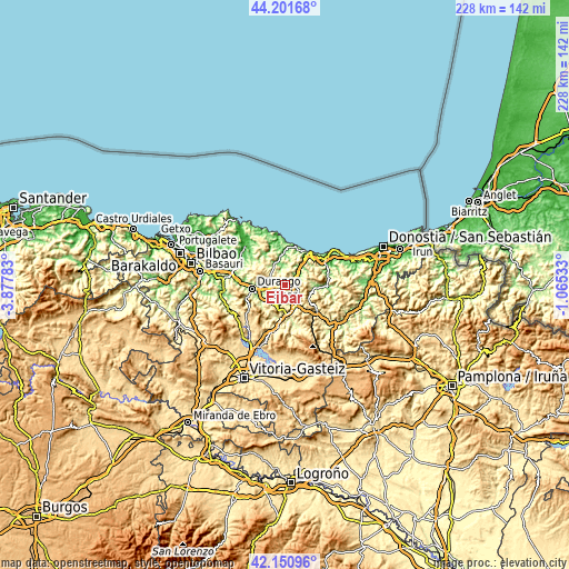
| \ | Map #1 | Map #2 | Topo.Map |
| Scale [m] | 66..765 m | 15..832 m | × |
| Scale [ft] | 217..2510 ft | 49..2730 ft | × |
| Average | 374.5 m = 1229 ft | 342.4 m = 1123 ft | × |
| Width | 7.13 km = 4.4 mi | 14.25 km = 8.9 mi | 228 km = 141.7 mi |
| Height | 7.13 km = 4.4 mi | 14.25 km = 8.9 mi | 228 km = 141.7 mi |
| ↑Max Latitude | 43.216964° | 43.248982° | 44.20168° |
| Latitude at center | 43.18493° | 43.18493° | 43.18493° |
| ↓Min Latitude | 43.152879° | 43.120811° | 42.15096° |
| ← Min Longitude | -2.515525° | -2.559471° | -3.87783° |
| Longitude center | -2.47158° | -2.47158° | -2.47158° |
| →Max Longitude | -2.427635° | -2.383689° | -1.06533° |
Nearby cities:
Cities around Eibar sort by population:
• Ermua elevation 181 m
2.5 km,  275°
275°
• Bergara 157 m
8.9 km,  150°
150°
• Elgoibar 48 m
5.9 km,  53°
53°
• Elorrio 192 m
8.3 km,  222°
222°
• Berriz 190 m
8 km,  255°
255°
• Mendaro 19 m
10.3 km,  42°
42°
• Antzuola 240 m
12.3 km,  142°
142°
• Abadiño 137 m
11.8 km,  251°
251°
• Markina-Xemein 90 m
9.4 km,  345°
345°
• Etxebarria 103 m
7.7 km,  356°
356°
• Elgeta 464 m
5.5 km,  194°
194°
• Zaldibar 421 m
5.4 km, 247°
Multilingual:
 En español:
Eibar elevación 133 m.
 En France:
Eibar élévation 133 m.


Sources and notes:
- [note 1] Map square and city borders are not equal. Map elevation data is calculated only from area inside that square.
- [src 1] Elevation data from geonames database provided with same terms of usage.
- [src 2] The elevation map of Eibar is generated using elevation data from NASA's 3 arcsec (90m) resolution SRTM data.
- [src 3] Base (background) map © OpenStreetMap contributors tiles are generated by Geofabrik and OpenTopoMap.
Copyright & License:
This Eibar Elevation Map is licensed under CC BY-SA. You may reuse any part from this page, if you give a proper credit by linking to this URL:
 More info on terms of use page.