El Castellar elevation
El Castellar (Aragon, Provincia de Teruel), Spain elevation is 1244 meters and El Castellar elevation in feet is 4081 ft above sea level [src 1]. El Castellar is a seat of a third-order administrative division (feature code) with elevation that is 641 meters (2103 ft) bigger than average city elevation in Spain.
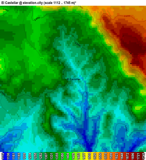
Below is the Elevation map of El Castellar, which displays elevation range with different colors. Scale of the first map is from 1112 to 1745 m (3648 to 5725 ft) with average elevation of 1336.6 meters (=4385 ft) [note 1]
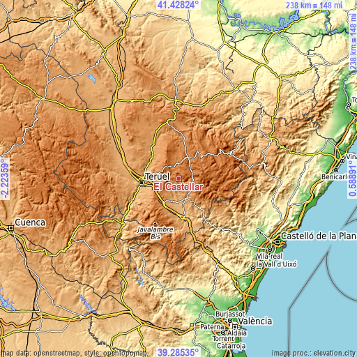
These maps also provides idea of topography and contour of this city, they are displayed at different zoom levels. More info about maps, scale and edge coordinates you can find below images.
| \ | Map #1 | Topo.Map |
| Scale [m] | 1112..1745 m | × |
| Scale [ft] | 3648..5725 ft | × |
| Average | 1336.6 m = 4385 ft | × |
| Width | 7.45 km = 4.6 mi | 238.3 km = 148.1 mi |
| Height | 7.45 km = 4.6 mi | 238.3 km = 148.1 mi |
| ↑Max Latitude | 40.398785° | 41.42824° |
| Latitude at center | 40.36531° | 40.36531° |
| ↓Min Latitude | 40.331818° | 39.28535° |
| ← Min Longitude | -0.861285° | -2.22359° |
| Longitude center | -0.81734° | -0.81734° |
| →Max Longitude | -0.773395° | 0.58891° |
Nearby cities:
Cities around El Castellar sort by population:
• Mora de Rubielos elevation 1036 m
13.9 km,  156°
156°
• Alcalá de la Selva 1403 m
8.3 km,  84°
84°
• Cedrillas 1359 m
8.5 km,  340°
340°
• Valbona 953 m
15.2 km,  177°
177°
• Formiche Alto 1089 m
7.9 km,  233°
233°
• Allepuz 1472 m
16.2 km,  28°
28°
• Valdelinares 1682 m
18.1 km, 80°
• Cabra de Mora 1082 m
5.4 km,  170°
170°
• Ababuj 1369 m
20.4 km,  2°
2°
• Corbalán 1267 m
14.8 km,  286°
286°
• Gúdar 1578 m
11.8 km,  44°
44°
• Monteagudo del Castillo 1447 m
10.1 km,  359°
359°
Multilingual:
 En español:
El Castellar elevación 1244 m.
 En France:
El Castellar élévation 1244 m.
 Auf Deutsch:
El Castellar höhe über dem Meeresspiegel ist 1244 m.

Sources and notes:
- [note 1] Map square and city borders are not equal. Map elevation data is calculated only from area inside that square.
- [src 1] Elevation data from geonames database provided with same terms of usage.
- [src 2] The elevation map of El Castellar is generated using elevation data from NASA's 3 arcsec (90m) resolution SRTM data.
- [src 3] Base (background) map © OpenStreetMap contributors tiles are generated by Geofabrik and OpenTopoMap.
Copyright & License:
This El Castellar Elevation Map is licensed under CC BY-SA. You may reuse any part from this page, if you give a proper credit by linking to this URL:
 More info on terms of use page.