Ababuj elevation
Ababuj (Aragon, Provincia de Teruel), Spain elevation is 1369 meters and Ababuj elevation in feet is 4491 ft above sea level [src 1]. Ababuj is a seat of a third-order administrative division (feature code) with elevation that is 766 meters (2513 ft) bigger than average city elevation in Spain.
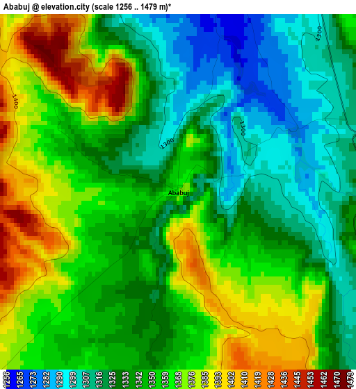
Below is the Elevation map of Ababuj, which displays elevation range with different colors. Scale of the first map is from 1256 to 1479 m (4121 to 4852 ft) with average elevation of 1346.9 meters (=4419 ft) [note 1]
These maps also provides idea of topography and contour of this city, they are displayed at different zoom levels. More info about maps, scale and edge coordinates you can find below images.
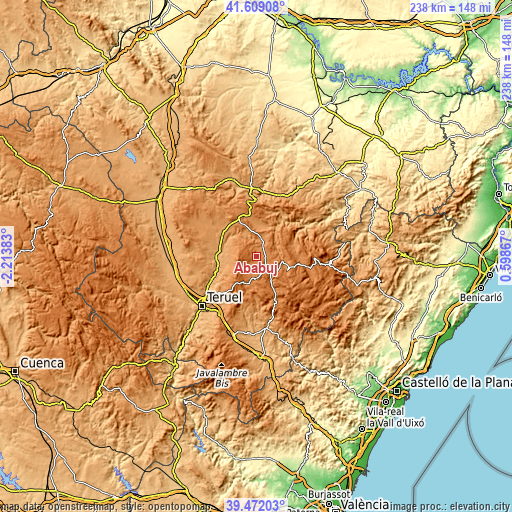
| \ | Map #1 | Topo.Map |
| Scale [m] | 1256..1479 m | × |
| Scale [ft] | 4121..4852 ft | × |
| Average | 1346.9 m = 4419 ft | × |
| Width | 7.43 km = 4.6 mi | 237.6 km = 147.6 mi |
| Height | 7.43 km = 4.6 mi | 237.6 km = 147.6 mi |
| ↑Max Latitude | 40.582463° | 41.60908° |
| Latitude at center | 40.54908° | 40.54908° |
| ↓Min Latitude | 40.51568° | 39.47203° |
| ← Min Longitude | -0.851525° | -2.21383° |
| Longitude center | -0.80758° | -0.80758° |
| →Max Longitude | -0.763635° | 0.59867° |
Nearby cities:
Cities around Ababuj sort by population:
• Cedrillas elevation 1359 m
13 km,  196°
196°
• Escorihuela 1137 m
13.8 km,  267°
267°
• Villarroya de los Pinares 1328 m
11.9 km,  100°
100°
• Orrios 1065 m
15.7 km,  286°
286°
• Hinojosa de Jarque 1215 m
15.8 km,  6°
6°
• Allepuz 1472 m
9.4 km,  131°
131°
• Galve 1198 m
13.4 km,  332°
332°
• Camarillas 1322 m
8.4 km,  32°
32°
• Gúdar 1578 m
14.1 km,  148°
148°
• Aguilar del Alfambra 1295 m
4.7 km, 12°
• Monteagudo del Castillo 1447 m
10.3 km,  184°
184°
• Jorcas 1340 m
4.7 km, 98°
Multilingual:
 En español:
Ababuj elevación 1369 m.
 En France:
Ababuj élévation 1369 m.


Sources and notes:
- [note 1] Map square and city borders are not equal. Map elevation data is calculated only from area inside that square.
- [src 1] Elevation data from geonames database provided with same terms of usage.
- [src 2] The elevation map of Ababuj is generated using elevation data from NASA's 3 arcsec (90m) resolution SRTM data.
- [src 3] Base (background) map © OpenStreetMap contributors tiles are generated by Geofabrik and OpenTopoMap.
Copyright & License:
This Ababuj Elevation Map is licensed under CC BY-SA. You may reuse any part from this page, if you give a proper credit by linking to this URL:
 More info on terms of use page.