Figueres elevation
Figueres (Catalonia, Província de Girona), Spain elevation is 41 meters and Figueres elevation in feet is 135 ft above sea level [src 1]. Figueres is a seat of a third-order administrative division (feature code) with elevation that is 562 meters (1844 ft) smaller than average city elevation in Spain.
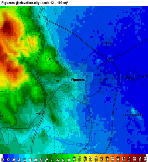
Below is the Elevation map of Figueres, which displays elevation range with different colors. Scale of the first map is from 12 to 199 m (39 to 653 ft) with average elevation of 48.9 meters (=160 ft) [note 1]
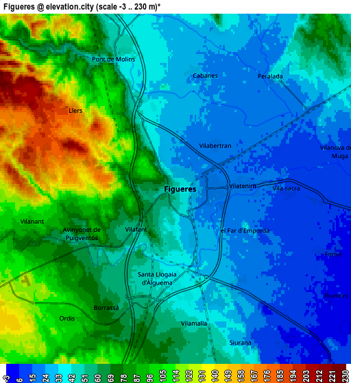
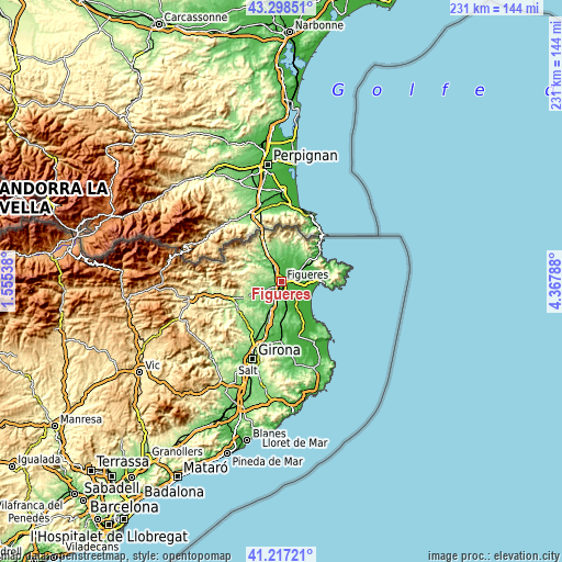
These maps also provides idea of topography and contour of this city, they are displayed at different zoom levels. More info about maps, scale and edge coordinates you can find below images.
| \ | Map #1 | Map #2 | Topo.Map |
| Scale [m] | 12..199 m | -3..230 m | × |
| Scale [ft] | 39..653 ft | -10..755 ft | × |
| Average | 48.9 m = 160 ft | 59.8 m = 196 ft | × |
| Width | 7.23 km = 4.5 mi | 14.46 km = 9 mi | 231.4 km = 143.8 mi |
| Height | 7.23 km = 4.5 mi | 14.46 km = 9 mi | 231.4 km = 143.8 mi |
| ↑Max Latitude | 42.298962° | 42.331458° | 43.29851° |
| Latitude at center | 42.26645° | 42.26645° | 42.26645° |
| ↓Min Latitude | 42.233921° | 42.201375° | 41.21721° |
| ← Min Longitude | 2.917685° | 2.873739° | 1.55538° |
| Longitude center | 2.96163° | 2.96163° | 2.96163° |
| →Max Longitude | 3.005575° | 3.049521° | 4.36788° |
Nearby cities:
Cities around Figueres sort by population:
• Vilafant elevation 54 m
2.9 km,  221°
221°
• Llers 167 m
5.2 km,  308°
308°
• Vilamalla 47 m
5.5 km,  172°
172°
• Vilabertran 22 m
2.4 km,  42°
42°
• Borrassà 75 m
5.6 km,  211°
211°
• Fortià 7 m
6.9 km,  112°
112°
• Pont de Molins 45 m
5.9 km,  333°
333°
• Vilanant 99 m
6.1 km,  257°
257°
• Peralada 37 m
6.1 km, 40°
• Cabanes 26 m
4.8 km,  15°
15°
• Vila-sacra 15 m
4.7 km,  90°
90°
• Avinyonet de Puigventós 71 m
4.3 km,  244°
244°
Multilingual:
 En español:
Figueres elevación 41 m.
 En France:
Figueres élévation 41 m.


Sources and notes:
- [note 1] Map square and city borders are not equal. Map elevation data is calculated only from area inside that square.
- [src 1] Elevation data from geonames database provided with same terms of usage.
- [src 2] The elevation map of Figueres is generated using elevation data from NASA's 3 arcsec (90m) resolution SRTM data.
- [src 3] Base (background) map © OpenStreetMap contributors tiles are generated by Geofabrik and OpenTopoMap.
Copyright & License:
This Figueres Elevation Map is licensed under CC BY-SA. You may reuse any part from this page, if you give a proper credit by linking to this URL:
 More info on terms of use page.